Brace yourself, Pacific Northwest. What’s left of a typhoon, which has made its way across the ocean, is expected to pummel parts of Oregon and Washington over the next several days.
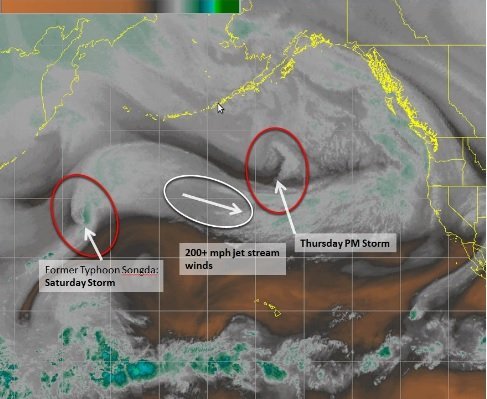
The National Weather Service Seattle warned of a one-two punch of storms for western Washington with the first storm beginning Thursday night into Friday.
The second storm, which is stronger, will pack the remnants of Typhoon Songda and strike the Pacific Northwest on Saturday with intense wind and rain.
There is growing confidence that the Saturday storm will move over Washington, according to the weather service.
If the storm crosses directly over or near western Washington, “this would be a worst-case scenario leading to a historical and destructive windstorm for the area,” it had warned earlier this week.
The winds from the second storm are likely to be fierce and widespread, according to CNN Weather.
“Coastal Washington, Oregon and the interior mountain ranges will feel the brunt of the strongest winds, possibly reaching hurricane strength (which is 74+ mph) by Saturday evening,” said CNN meteorologist, Derek Van Dam.
“Damaging winds will still be possible across the Seattle metro region, but will experience gusts between 50 to 60 miles per hour.”
Seattle began hunkering down for the double barrel of storms, by shutting its parks, preparing emergency resources and opening more slots at its homeless shelters.
The possibility that the Saturday storm could be “one of the severest weather events that we’ve ever had has caused us to step up our response significantly,” said Seattle Mayor Ed Murray in a press conference Thursday.
Rain pelted the northwest Thursday as the National Weather Service warned of high winds ranging from 30 to 70 mph. The winds on Thursday night reached 82 mph in Crystal Mountain and 48 mph in Hoquiam, Washington.
Saturday’s storm is expected to drench Washington all the way down to northern California. It could pose dangers including falling trees, downed wires, power outages and floods.
The storms could produce high seas potentially reaching 30 feet or higher, and coastal flooding along areas of Washington, according to CNN Weather.
A third storm may pass through the Pacific Northwest next week, said CNN meteorologist Dave Hennen.


