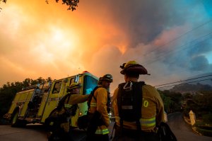
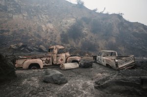
Thousands of Santa Barbara County residents remained under evacuation orders as the Thomas Fire burned a total of 270,000 acres — about 422 square miles — as of Sunday evening, authorities said.
The blaze was 45 percent contained, according to fire officials.
The massive wildfire — which is one of the largest in state history — first started in Ventura County earlier this month, breaking out on the evening of Dec. 4. It spread rapidly, triggering the evacuation of thousands in the county and leaving a trail of destruction as homes were reduced to rubble, power outages went on for days and blankets of smoke and ash could be felt in the air.

Two deaths have been linked to the blaze — a 70-year-old Santa Paula woman and a fallen firefighter from the San Diego area.
As strong Santa Ana winds complicated containment efforts, the fire moved north toward Santa Barbara County this past week, continuing to threaten coastal communities near the county’s border with Ventura. On Saturday, many remaining evacuations in Ventura were lifted while residents in the Montecito and Summerland area faced mandatory evacuations.
No changes were made to those evacuations by about 6 a.m. the following morning.
So far it has destroyed 756 single-family homes, with another 189 homes damaged, fire officials said early Sunday morning.
That size inches even closer to the mass of the largest California fire on record — the 300,000-acre Santiago Canyon Fire in 1889. It’s even closer in acreage to the 273,000-acre Cedar Fire in 2003, which is the largest blaze on a list dating back to 1932 that Cal Fire officials say is more reliable, the Los Angeles Times reports.

Battling the Thomas Fire has cost more than $123 million as just over 8,500 firefighters continued working to contain it Sunday, officials said.
At the scene of the blaze in Santa Barbara, a firefighter told KTLA that containment efforts went fairly well Saturday night as there were not so-called ‘sundowner winds,’ which are described by national weather officials as warm, dry offshore winds unique to the Santa Barbara coastline.
“Last night was a good night for us,” said Jay Smith of Cal Fire. “We didn’t get the sundowner winds … it helped lay the fire down.”
“It definitely is a turning point for us,” he said.
While the blaze came a bit under control, an update from fire officials the following morning said a red flag warning will remain in place as high winds and low humidity are expected — conditions which typically spur fire growth.
Thirty-four helicopters, six air tankers and two super scoopers are being used by firefighters to try putting out the flames, officials said.
#ThomasFire– A Bombardier 415 Superscooper makes a water drop Sunday morning on hot spots along the hillside east of Gibraltar Road. pic.twitter.com/rPKp5asdDA
— SBCFireInfo (@EliasonMike) December 17, 2017
Coastal communities in Santa Barbara County are of most “concern,” fire officials said, with these including the cities of Santa Barbara, Montecito and Summerland as well as areas around Matilija Wilderness, Rose Valley and the Sespe river drainage north of Fillmore.
But the blaze continues to threaten parts of Ventura County near Fillmore, especially as some areas around Los Angeles and Ventura counties are seeing gusts at speeds close to 60 mph.
Red Flag Warnings in effect for much of LA/Ventura counties until 8 pm this evening. Potential for very rapid fire spread, long range spotting, and extreme fire behavior due to strong #SantaAnaWinds. #LAWind #LAWeather
— NWS Los Angeles (@NWSLosAngeles) December 17, 2017

Meanwhile, the air quality in fire-affected areas of Santa Barbara County ranges from moderate to unhealthy for sensitive groups, such as those with a lung condition. In Ventura County, where some coastal areas are still seeing ash-covered cars and buildings, the air quality is worse. It is considered “unhealthy” in cities including Ventura, Oxnard, Camarillo, Santa Paula and Ojai, according to air pollution officials from the Environmental Protection Agency.
Mandatory Evacuations (as of 7 a.m. Sunday morning):
Santa Barbara County
City of Santa Barbara — the area east of Hwy 154 to Mission Canyon Road
Montecito and Summerland Area — south of Hwy 192, north of Hwy 101, west of Toro Canyon and east of Summit Road and Country Club
Montecito — north of Alameda Padre Serra/Hwy 101, south of Hwy 192, east of Mission Canyon Road and west of Hot Springs and Summit Road
City of Ventura
North of Foothill Road from Cobble Road to Kimball Road
Unincorporated Areas of Fillmore
Sespe Creek to the west, Burson Ranch to the east, Fillmore City limits to the south, and Los Padres National Forest boundary to the north.
Unincorporated Ventura County
Residents and day visitors of Rose Valley
Unincorporated Areas of Fillmore
Hall Road to the west, Sespe Creek to the east, Fillmore City limits to the south, and Los Padres National Forest boundary to the north.
Voluntary Evacuations
Santa Barbara County
Santa Barbara City — from West Mission Street, east to South Salinas Street from Hwy 101 to Alameda Padre Serra
West of Santa Barbara City — north to San Marcos Rd to Hwy 154 and north of Cathedral Oaks Rd to the intersection of Hwy 154 and north to San Marcos
The area from Constance/Alameda Padre Serra/South Salinas on the north and east, Hwy 101 on the south and West Mission Street to State Street on the west
All areas south of 101 to the coast and west of the zoo to San Ysidro Road
Animal evacuations are being handled at the Ventura County Fairgrounds located at 10 West Harbor Boulevard in Ventura. Information about road and school closures, air quality conditions and other issues related to the fire can be found on the Santa Barbara County website.


