New projections from the National Oceanic and Atmospheric Administration released this week show persistent drought conditions lingering in the western U.S. through at least early fall, a dire forecast for the already parched region.
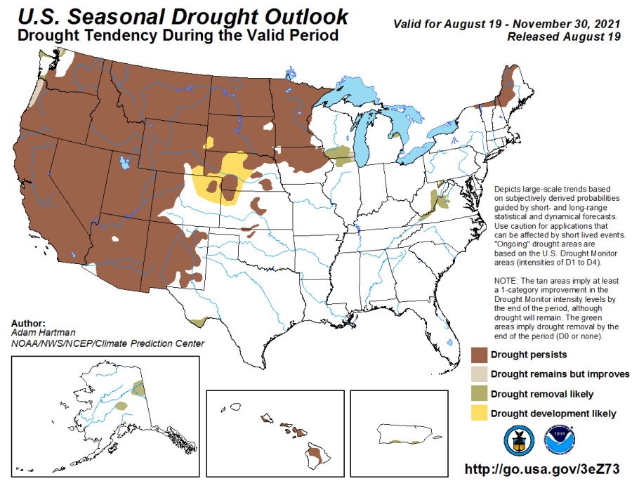
NOAA’s Climate Prediction Center released new maps Thursday providing a temperature and precipitation outlook for the period between Aug. 19 and Nov. 30. The projections show a high likelihood of warmer and drier than normal conditions across much of the West, stretching north to the Canadian border.
Researchers from NOAA’s National Integrated Drought Information System say the region may see some signs of improvement along the Oregon and Washington coast, but most of the nation’s hardest-hit drought zones won’t get relief.
“The big picture: Drought is expected to persist through November just about everywhere,” NIDIS tweeted.
Drought conditions are also likely to develop in some adjacent areas, the forecast showed.
A staggering 98% of the West is in some type of drought, with a quarter of the region experiencing the most severe category of “exceptional drought,” according to the U.S. Drought Monitor.
Those conditions are especially pronounced in California, with 100% of the state currently in some type of drought, data from the federal monitor showed. Approximately 88% of the Golden State is mired in extreme drought, and nearly half is experiencing exceptional drought.
NOAA’s outlook map shows existing drought conditions will be locked in throughout the western U.S. in the coming months, meaning there will be little to no improvement to California and other states experiencing severe drought anytime soon.

In recent weeks, NOAA forecasters have expressed increased confidence in the formation of a La Niña weather pattern for late fall into winter.
La Niña is the name given to a pattern of colder-than-average sea surface temperatures in the central and eastern equatorial Pacific Ocean. The result is a change in expected seasonal conditions, often drying out the southern states and providing wetter conditions along a northern jetstream.

Such a pattern could bring relief to the Pacific Northwest, but likely won’t help parched states in the southwest and along the southern border as fall turns to winter.
In the southern tier — a region that includes Southern California — there’s an approximately 40% chance of below-average precipitation, according to NOAA climate scientist Michelle L’Heureux.
“You might think 40% doesn’t seem that large, but remember we have three possible outcomes: below average, near average and above average,” she explained. “It’s not a coin flip. There are three potential outcomes. That means randomly you can get 33%, so a 40% chance really does mean we favor below-average conditions.”
If NOAA’s predictions comes to fruition, this would mark the second straight winter that the U.S. will be gripped by a La Niña weather pattern.
