Southern California will remain shrouded in smoke this weekend as two forest fires continue to burn after erupting during last week’s record heat, officials said.
Air quality will stay poor as the Bobcat Fire in the Angeles National Forest nears 30,000 acres in size with little containment. In the San Bernardino Mountains, crews have gained better control of the 14,000-acre El Dorado Fire.
Other massive wildfires are burning elsewhere in California, where officials say record-breaking blazes have scorched an area larger than the state of Connecticut since the beginning of the year. At least 19 people have died and more than 4,000 structures have been destroyed since Aug. 15, according to state authorities.
All 18 national forests across California shut down this week in an unprecedented move by U.S. Forest Service officials and will remain closed until Monday.
“This is a climate damn emergency,” Gov. Gavin Newsom said.
Here’s what you need to know locally:
Smoke poses health hazard
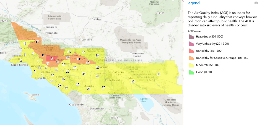
Air quality will range from moderate to unhealthy across the region on Saturday and Sunday, according to the South Coast Air Quality Management District.
Air quality can change by the hour, and the public can check conditions in their area on airnow.gov.
Officials have issued a smoke advisory every day since the El Dorado and Bobcat fires erupted last weekend and brought ash, dust and debris across the region. Additionally, smoke from wildfires in Northern and Central California is making its way south.
“Breathing in smoke can aggravate lung disease, cause asthma attacks, cause acute bronchitis, and increase the risk of respiratory infections,” the National Weather Service warned. “Avoid prolonged exposure, especially for sensitive populations such as children, elderly, and people with respiratory or heart disease. Avoid strenuous activities and use common sense.”
SCAQMD’s website has more tips on protecting yourself from wildfire smoke.
“The good news is that temperatures will be near seasonal normals,” NWS said.
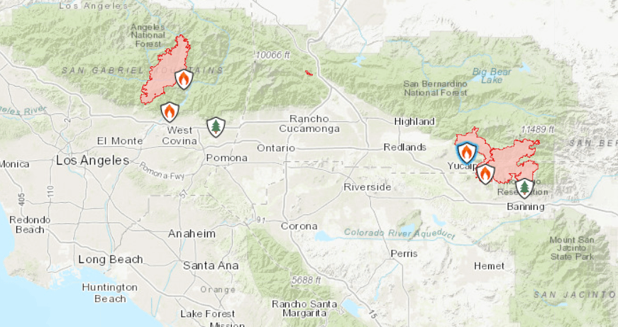
Bobcat Fire: 29,245 acres, 0% contained
Crews battling the Bobcat Fire on steep terrain expect “extreme fire behavior and rapid rates of spread” on Saturday as conditions remain warm and dry, according to the federal website InciWeb. Dry fuels in parts of the area haven’t burned for 60 years, the site said.
According to officials, the fire has been growing mostly on the north and south ends. The chances of spreading to the east and west are lower because flames are burning on old burn scars, authorities said.
More than 760 personnel are assigned to the fire. They planned to work on containing the flames to the south from Mount Wilson to the foothill line. On the north end, crews will work on keeping the flames south of Highway 2 and west of Highway 30.
Crews on Friday focused on keeping flames that were burning downhill away from populated areas as winds pushed the fire northeast, authorities said. Two aerial units worked on controlling the southwest perimeter.
Monrovia, Arcadia, Bradbury, Sierra Madre, Altadena, Duarte and Pasadena remain under evacuation warnings, and several roads are still closed. Residents can sign up for alerts from the county on lacounty.gov/emergency/alert-la.
Temperatures will cool down slightly on Sunday, officials said.
What caused the fire is still under investigation after it exploded near Cogswell Dam around noon last Sunday. Authorities have not reported any injuries or damages to structures.
El Dorado Fire: 14,043 acres, 39% contained
Calm conditions overnight enabled the nearly 1,500 firefighters deployed to the El Dorado Fire to make “good progress on securing the fire line.” But officials braced for winds that could spread the fire starting Saturday afternoon, according to an update on InciWeb.
Crews continued to secure the fire line on the ground as aerial units dropped water and retardant to slow the spread of the flames, authorities said.
For structure protection, officials have set up a dozer line north of the fire perimeter and south of Angeles Oaks along the Highway 38, officials said.
Crews are also patrolling the south side of the Yucaipa ridge, putting out any hotspots or flare-ups.
A portion of Yucaipa remains under evacuation orders. Other parts of the city, as well as some neighborhoods in Mentone, are under an evacuation warning.
San Bernardino County residents can sign up for emergency alerts on sbcounty.gov/SBCFire and Riverside County residents on rivcoready.org/AlertRivCo.
Investigators have determined the source of the fire to be a pyrotechnic device used during a gender reveal party at El Dorado Ranch Park last Saturday. Flames have destroyed at least four homes and six outbuildings or minor structures, damaging two other residences and four other smaller structures.


