The first of two powerful storms made its way into Southern California Thursday morning.
“I would not be surprised if we get half of our water total for the year out of these two storms,” KTLA Meteorologist Henry DiCarlo said.
The reason forecasters are calling so much moisture is because the storms will be pulling in water vapor from an atmospheric river, increasing its rain potential.
“Atmospheric rivers are graded on a scale of one to five,” said Henry, who described Thursday’s conditions as an AR-4.
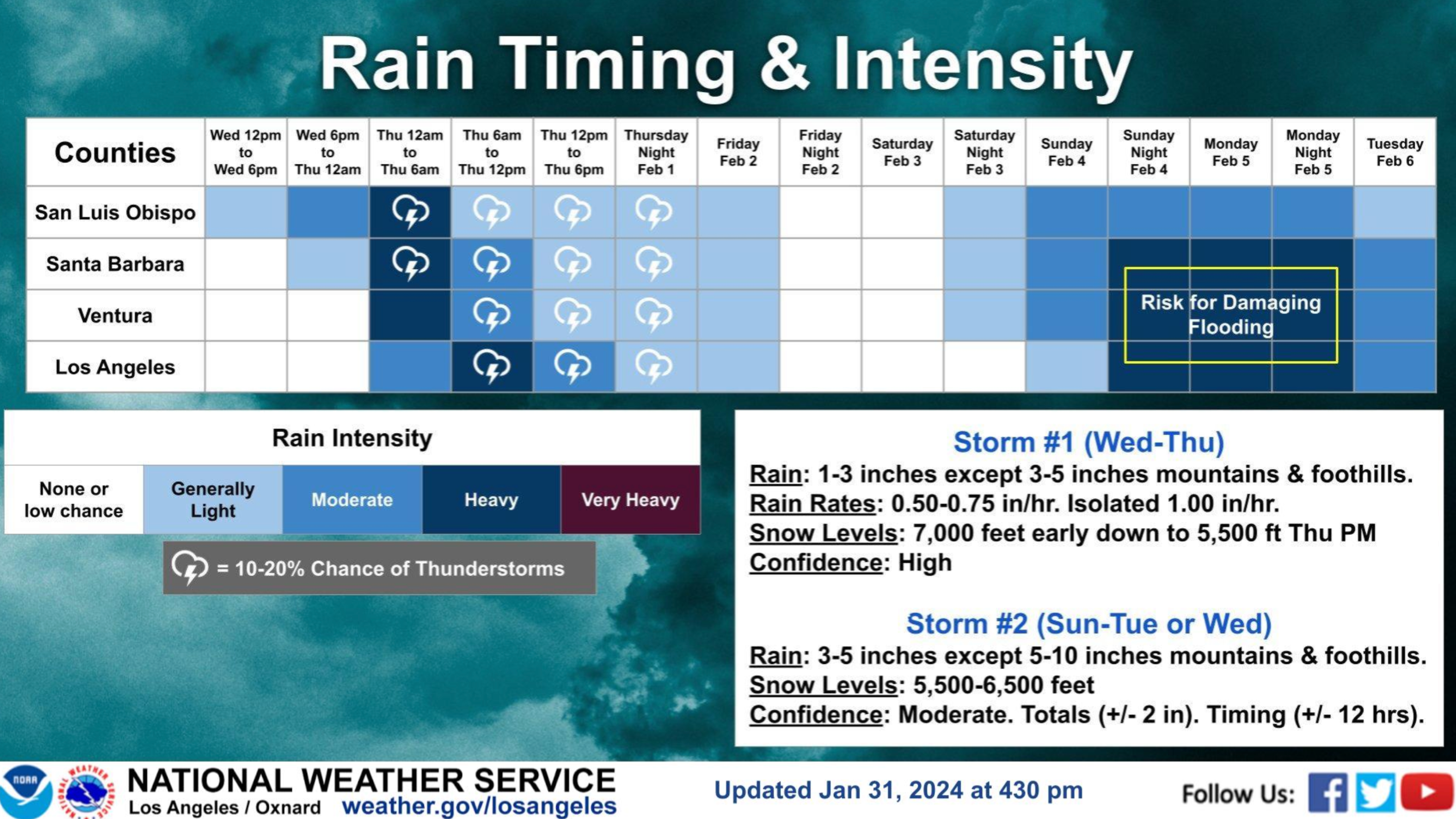
This first storm could bring from 1 to 3 inches of rain to our coast and valley regions on Thursday alone. Mountain and foothill areas could see up to 5 inches of rain, according to the National Weather Service.
“The winds are coming in from the coast and pushing the moisture up the mountain tops. When this happens, we squeeze a lot of it out of the clouds. So, our mountain communities and foothill communities will get a lot of rain and a lot of snow,” Henry said.
The heaviest rain is expected to fall during the morning hours but continued showers, along with possible thunderstorms and gusty winds linger through the afternoon. “There’s a lot to this storm,” Henry said.
The storm was off to a good start Thursday morning with measurable rain being recorded as of 10:30 a.m. at the following locations:
- Downtown Los Angeles 1.41 inches
- Huntington Beach 1.57 inches
- Northridge 1.30 inches
- Ontario 0.97 inches
- Oxnard 1.98 inches
- Thousand Oaks 2.13 inches
Flooding prompted the closure of a portion of the Pacific Coast Highway through Bolsa Chica Ecological Reserve area in Huntington Beach Thursday morning.
It was unclear when the roadway would reopen.
Winter storm warnings and winter weather advisories have been issued for our local mountain areas through 10 p.m. Thursday.
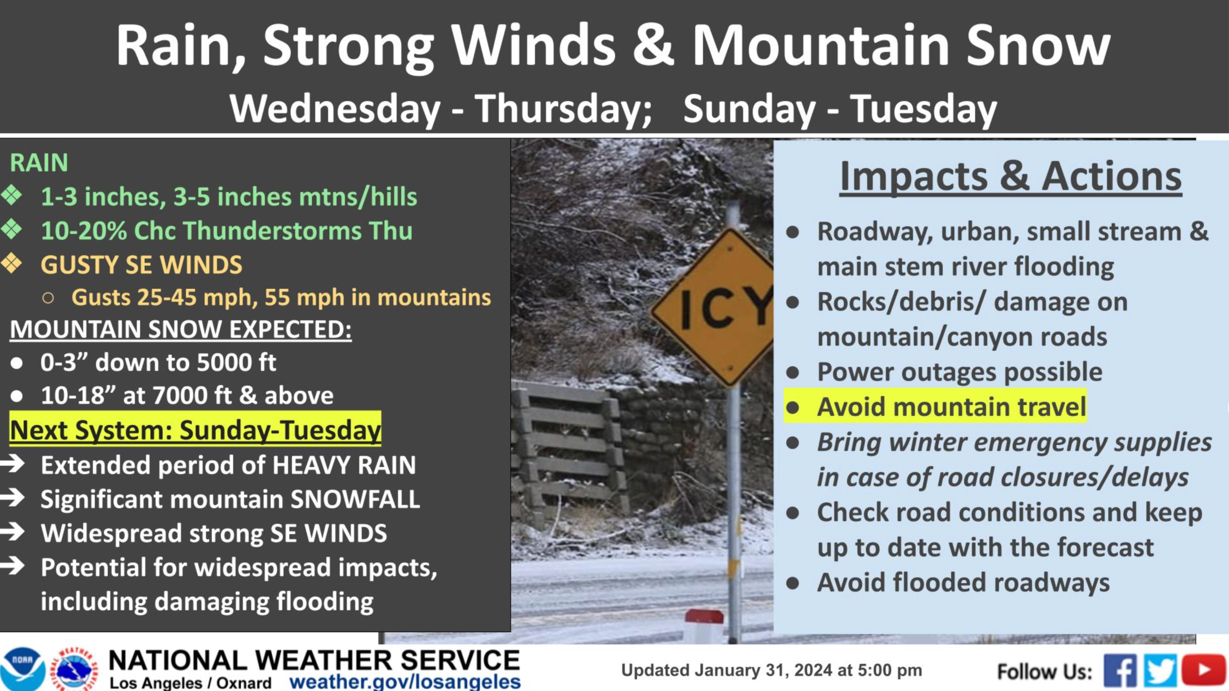
Measurable snow could fall as low as 5,000 feet, according to the weather service.
Significant snowfall between 10 and 18 inches is forecast above the 7,000-foot level.
A couple of inches of snow could also fall on the Grapevine, impacting traffic on the 5 Freeway.
Motorists are being urged to avoid mountain travel if possible. Otherwise, officials say to bring winter emergency supplies in case of road closures or delays.
As dangerous as this first storm appears to be, a second, even stronger system, will arrive late Sunday, bringing a couple of days of rain.
“Really, the greatest risk is going to be Monday and Tuesday next week,” Henry said.
Forecasters are calling for that storm to bring 3 to 5 inches of rain to our coasts and valleys and up to 10 inches of rain along the foothills and in the mountains.
A short break of dry weather and mostly sunny skies is on tap for Friday afternoon and Saturday.


