La Niña is expected to stick around for at least a little while longer, with the transition back to neutral conditions most likely not taking place until at least later in spring.
That’s according to the latest forecast from the National Oceanic and Atmospheric Administration’s Climate Prediction Center forecast, which was released late last week.
NOAA says there’s an approximately 77% chance that La Niña conditions will linger between March and May. Forecasters also favor the transition back to neutral occurring from June to August, giving that a 57% chance.
This is the second consecutive winter with a La Niña event, which unfortunately for drought-stricken Southern California usually means below-average precipitation for the region during its traditionally wettest months. That’s what happened in the Golden State last year, which was among the driest ever recorded.
The winter got off to a promising start with a series of powerful storms that replenished the ever-important Sierra Nevada snowpack and improved California’s overall drought outlook. But January and February have been largely bone dry for the state — though heavy rain hit parts of the Southland Tuesday — and the snowpack is once again below normal for this time of year.
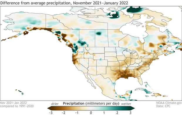
“The precipitation map for November–January also looks a fair bit like the typical La Niña impacts map for this season. Lots of rain and snow in the Pacific Northwest, substantially drier than average through the south-central and southeastern states,” Emily Becker of NOAA’s CPC wrote in the agency’s ENSO blog.
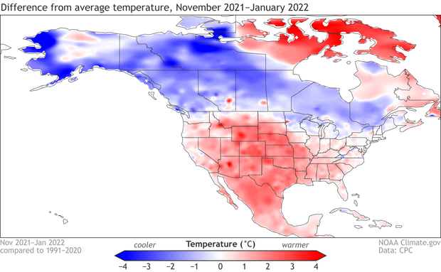
Since the start of winter, temperatures across California have also been below average for this time of year, according to NOAA.
While cooler temperatures and wet weather may have prevailed Tuesday in the Southland, the region just emerged from a record-setting heat wave that brought widespread highs of the 80s and even low-90s late last week.
The warm, dry winter in Southern California shouldn’t come as a surprise, however, as the conditions are largely consistent with the seasonal outlook released by the Climate Prediction Center back in November.
La Niña comprises one end of the El Niño Southern Oscillation (ENSO) cycle, and it’s marked by cooler sea surface temperatures in the tropical Pacific Ocean. On the other end of the cycle is El Niño, which happens when sea surface temperatures are warmer. In between, there’s the third state known as “neutral.”
There have now been five straight three-month periods where the Oceanic Niño Index exceeded the La Niña threshold, which is -0.5 degrees Celsius, NOAA reported.
La Niña conditions started to develop last September, and at the time, the agency gave the climate pattern a 50-50 chance of continuing into spring. That prediction, too, appears to be coming to fruition.
Back-to-back La Niña events aren’t necessarily unusual, and experts are already looking ahead to the possibility of conditions developing for a third straight year following a return to ENSO-neutral. However, it’s still too soon to tell whether there will be a three-peat.
“We still don’t have a very clear picture of that,” Becker wrote. “By fall (September–November), neutral still has the edge, but forecasters can’t currently give any category a strong chance.”


