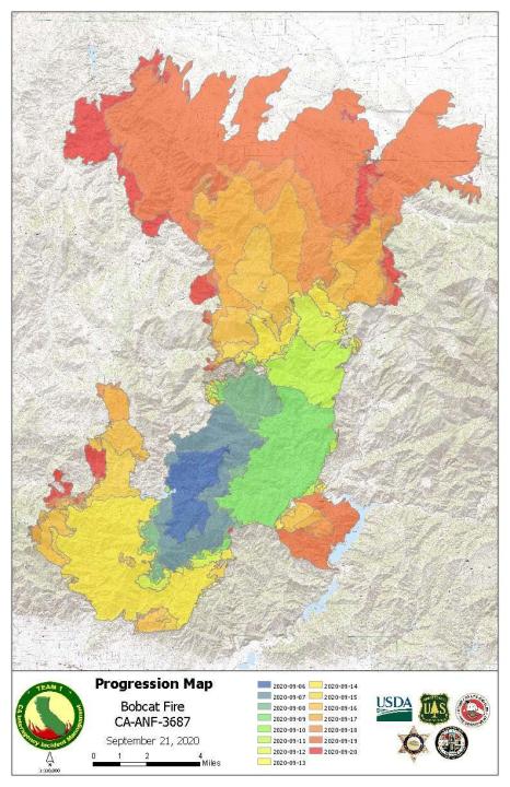
The Bobcat Fire grew by nearly 2,800 acres Tuesday to cover more than 175 square miles as crews continued operations to increase containment and protect the Mount Wilson Observatory.
But containment remained steady at 17% Tuesday evening, after firefighters had been able to raise it from 13% overnight, according to the U.S. Forest Service’s incident website.
The Bobcat Fire, which has been burning for nearly three weeks in the Angeles National Forest, consumed homes as it spread north into the Antelope Valley last week.
On Tuesday, the fire was less active due to lower temperatures, increased humidity and lighter winds. Later in the day, conditions became favorable enough to conduct strategic firing north of Mount Wilson, firefighters said.
Weather conditions are expected to worsen over the remainder of this week, becoming progressively warmer and drier it heats up significantly Saturday, when gusty winds could arrive, officials said.
Engines would be stationed overnight in the desert foothills to monitor for flare ups and to respond to smoke checks in neighborhoods.
More than 1,500 firefighting personnel are at the scene battling the blaze, but officials say there is still a critical need for more resources.
The fire continues to threaten the Mount Wilson area as well as infrastructure near State Route 2 and several foothill communities. Crews plan to spend Tuesday focusing on structure protection.
About 1,000 homes were threatened as of Monday night, according to the Forest Service. Evacuation orders were issued for residents south and west of Upper Big Tujunga Canyon, east of Angeles Forest Highway and north of Angeles Crest Highway.
At least 29 structures have been destroyed in northeastern Los Angeles County and that number could grow to 85, the Los Angeles Times reported.
Over the weekend, the fire destroyed the nature center at Devil’s Punchbowl Natural Area. Some homes were also destroyed in the Antelope Valley.
The South Coast Air Quality Management District continues to keep a smoke advisory in place over the region due to the Bobcat Fire, as well as the El Dorado Fire in the San Bernardino Mountains and the Snow Fire in the San Jacinto Wilderness.
The cause of the Bobcat Fire, which started on Sept. 6, is still under investigation.
Evacuation orders
The following areas remain under evacuation orders as of Tuesday afternoon:
- Angeles Crest Highway, between Angeles Forest Highway and Highway 39.
- Unincorporated areas of Crystal Lake, East Fork of the San Gabriel River and Camp Williams.
- The communities of Pearblossom, Juniper Hills, Valyermo and Llano (except for the Longview section).
- South and west of Upper Big Tujunga, east of Angeles Forest Highway and north of Angeles Crest Highway.
Evacuation warnings
The following areas remain under evacuation warnings as of Tuesday afternoon:
- Pasadena/Altadena: north of Sierra Madre Boulevard, west of Michillinda Avenue, east of Washington Boulevard, north of New York Drive and north of New York Drive and Woodbury Drive, east of Hahamongna Watershed Park.
- Community of Wrightwood.
- Littlerock: south of Pearblossom Highway, north of Weber Ranch Road, east of Cheseboro Road and west of 87th Street east.
- South of Highway 2, north of Blue Ridge Truck Trail, east of Highway 39 and west of the Los Angeles County border.
- Longview: south of Avenue U-8, north of East Avenue W-14, east of 121st East and west of 155th Street East
- South of Pearblossom Highway, south and east of Pearblossom Highway, north and west of Mt. Emma Road, north and east of Angeles Forest Highway and west of Cheseboro Road.
- South of Mt. Emma Road, north of Upper Big Tujunga Canyon Road, east of Angeles Forest highway and west of Pacifico Mountain.


