For the first time in more than a year, all of California is out of the worst drought category as the state’s overall outlook shows major improvement since the start of the water year.
As of Tuesday, when the U.S. Drought Monitor released its latest map, 0% of the Golden State was experiencing “exceptional” drought — something that hasn’t happened since Dec. 8, 2020.
Additionally, only approximately 1.4% is in the second-worst “extreme” drought category, data from the the federal monitor shows.
But while California may be largely out of the worst conditions, virtually all of the state continues to be mired in moderate to severe drought, according to the latest map.
Below, you can see the difference between how California looked at the end of the 2020-2021 water year versus latest conditions measured on Jan. 11.

When that first map was released, California was still in the midst of one of its driest years on record, according to the state’s Department of Water Resources.
The result was more than 45% of the state was in the monitor’s worst drought category when the water year began, with over 87% mired in at least severe drought.
But a barrage of storms last month brought record-breaking rain and snow to parts of the state, wiping out the worst of the drought conditions and significantly bolstering the Sierra snowpack, which helps replenish critical source of California’s water supply.
“We could not have asked for a better December in terms of Sierra snow and rain,” DWR Director Karla Nemeth said in a news release. “But Californians need to be aware that even these big storms may not refill our major reservoirs during the next few months. We need more storms and average temperatures this winter and spring, and we can’t be sure it’s coming.”
To make up for the last two years — which each ranked among the five driest on record — the state needs “significant January and February precipitation,” according to the release.
As California water officials recently noted, the state has gotten off to fast starts precipitation-wise in December before, only to see bone dry conditions for the rest of winter and beyond.
The bad news for California: This winter already wasn’t expected to be a wet one.
In fact, according to the seasonal outlook from the National Oceanic and Atmospheric Administration’s Climate Prediction Center, the probability favors it to be drier-than-normal for most of California because of a La Niña event.
You can see the winter precipitation forecast below:
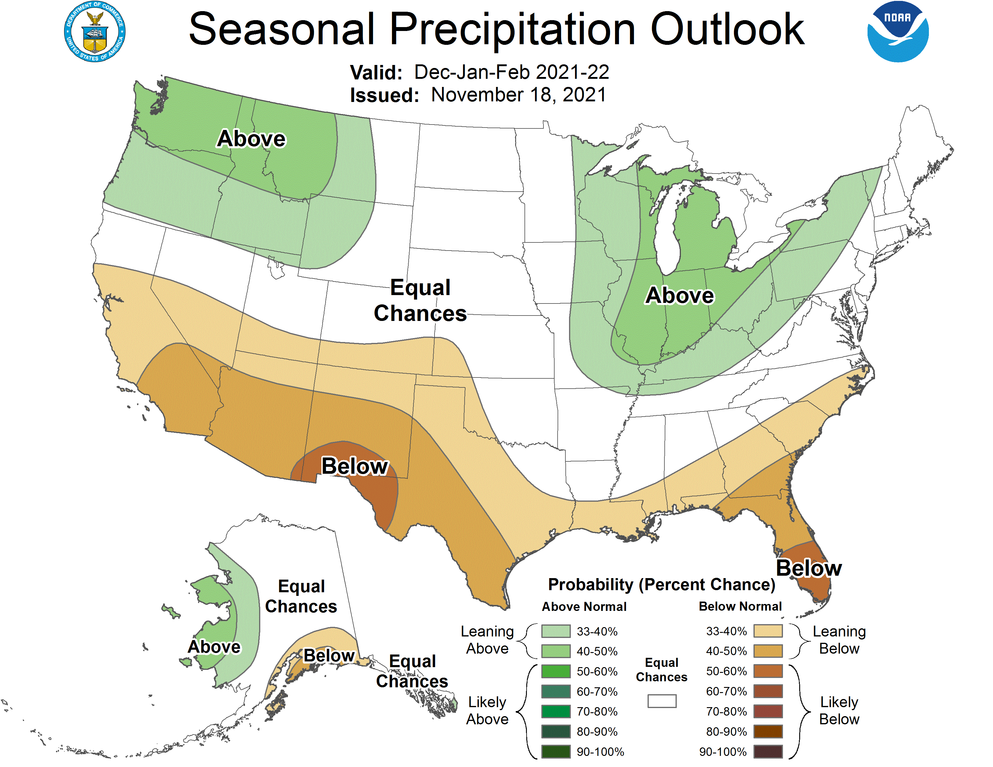
This is the second winter in as many years that La Niña conditions have emerged. For Southern California, that typically translates to drier weather, as was the case in 2021.
NOAA’s seasonal outlook also predicted that the drought will likely continue to persist for most of California, with only the northernmost part of the state showing any improvement.
As of mid-January, La Niña conditions are near their peak, according to NOAA. However, the event it expected to stick around for another few months, with ENSO neutral conditions favored to return sometime in spring, experts say.


