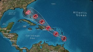
Tropical Storm Dorian is expected to strengthen into a Category 2 hurricane as it heads toward the southeastern US over the Labor Day weekend.

After hitting Puerto Rico, the storm is forecast by Friday morning to strengthen into a Category 1 hurricane as it tracks to the east of Turks and Caicos, then to continue to build through Sunday morning before possibly making landfall late Sunday or Monday along the east coast of Florida or points north, CNN meteorologist Haley Brink said.
Though it’s too early to know precisely when and where the storm might affect the US mainland, Florida’s governor on Tuesday said it’s time for his state to being prepping.
“Based on the current track of Tropical Storm Dorian, all residents on the East Coast should prepare for impacts, including strong winds, heavy rain and flooding,” Gov. Ron DeSantis said. “Make sure to have your supplies ready and follow @FLSERT (Florida Division of Emergency Management) and local media for the latest updates on the forecast.”
A Category 2 hurricane has sustained winds of 96 to 110 mph.
A well-known forecast model predicts Dorian will pack hurricane-force winds when it reaches the Florida Peninsula. The model operated by the European Center for Medium Range Forecasting shows the center of a strong storm coming ashore along the eastern coast of Florida, somewhere between West Palm Beach and Jacksonville.
Still, “it is still way too early to forecast impacts” in Florida, CNN meteorologist Dave Hennen said.
Dorian on Wednesday was approaching islands in the Caribbean.
The system was set to slam Puerto Rico’s eastern half Wednesday afternoon with heavy rains — and potentially flooding and landslides — along a similar path and with impacts to many of the areas hardest hit two years ago by Hurricane Maria.


