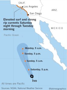
A southeast swell from Tropical Storm Ivo will generate elevated surf and hazardous rip currents this weekend at Southland beaches, according to the National Weather Service.
Ivo was about 300 miles west-southwest of Cabo San Lucas on Saturday morning. Southerly swell from about 165-170 degrees is expected to arrive in Southern California late Saturday and last through Tuesday, peaking Sunday afternoon through Monday morning. Surf heights will be about 4 to 6 feet with a 14-second period, with 6 to 8 feet possible, especially in L.A. County.
Hazardous rip currents will make swimming treacherous, and big waves will break over rock jetties. Flooding is possible with afternoon high tides in low-lying areas, according to the weather service. Beach erosion is also possible.
Read the full story on LATimes.com.

Tropical Storm #Ivo is expected to weaken to a Tropical Depression by Saturday night as it continues to move to the north northwest. The only impacts to our area will be elevated surf, mainly on the Orange County beaches, and increasing high clouds. #CAwx #tropicalwx pic.twitter.com/I7bM8zkIbQ
— NWS San Diego (@NWSSanDiego) August 24, 2019
SE swell from Tropical Storm #IVO is still expected to impact our coast Sun-Tue!! #SoCal #CAwx #surf pic.twitter.com/0RFQCSGvy8
— NWS Los Angeles (@NWSLosAngeles) August 23, 2019
If you're heading to the beach this weekend (or anytime in general) make sure you always swim near a lifeguard! #cawx https://t.co/vjJVtk960m
— NWS San Diego (@NWSSanDiego) August 23, 2019


