A tropical storm warning was issued in Southern California for the very first time on Friday night as Hurricane Hilary is set to make landfall this weekend.
Southern Californians should start feeling the remnants of Hilary on Saturday as cloud coverage increases and light rain starts to fall. Stronger showers are expected to move in on Sunday with the heaviest rain forecast to fall late Sunday into Monday.
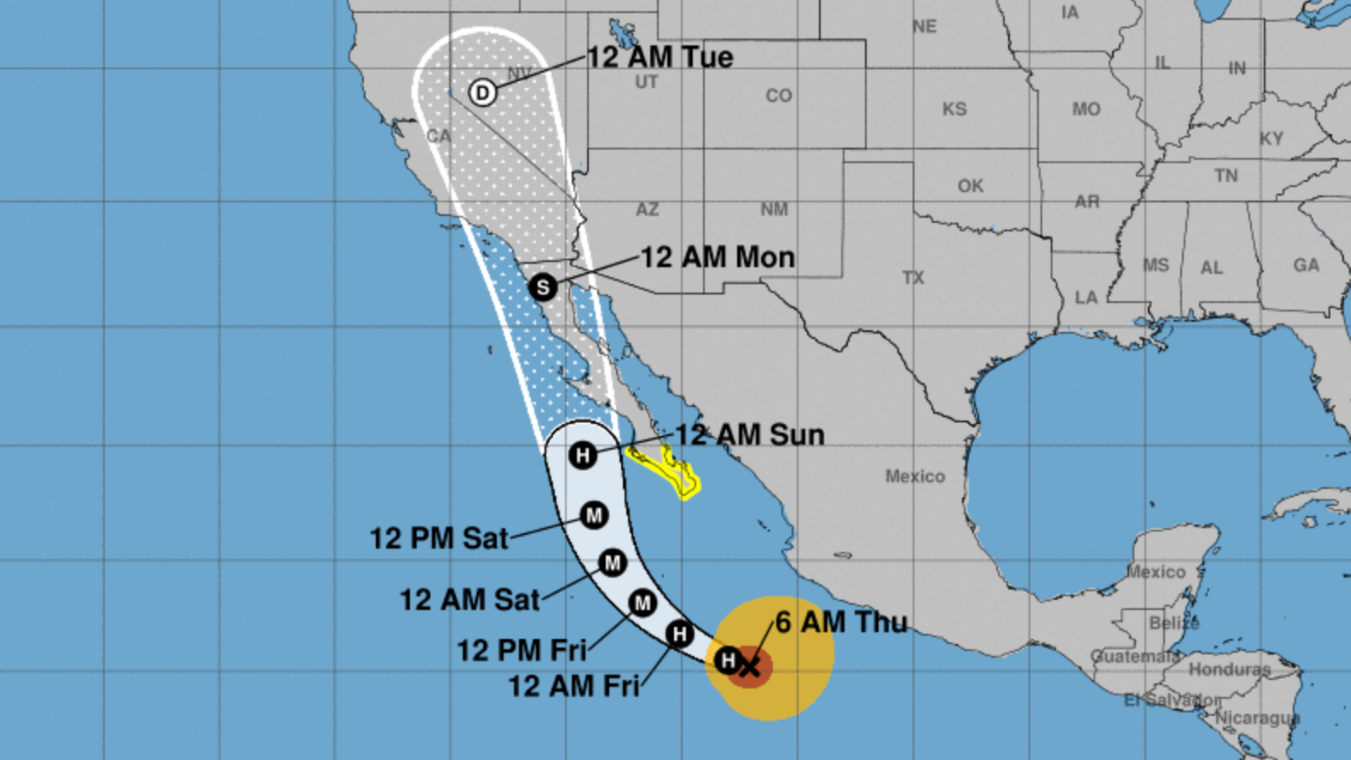
Currently a Category 4 hurricane, Hilary is forecast to head north along Mexico’s Baja Peninsula and reach California on Sunday.
Los Angeles Mayor Karen Bass spoke on Friday to discuss the city’s preparation for the incoming storm alongside general managers of city departments.
“The city of L.A. is mobilizing in advance of the landfall of Hurricane Hilary,” Bass said Friday. “This is potentially an unprecedented, extreme weather event for Los Angeles, Southern California and the rest of the West Coast. The city is prepared. We’re not waiting for the storm to hit. We’ve already begun working 24/7 to be ahead of the curve and to be ready as soon as the storm reaches our shores.”
According to weather officials, Hilary’s window for tropical storm-force winds is expected to be Sunday afternoon until early Monday morning.
NWS has advised residents in these areas to plan for hazardous wind by preparing their properties ahead of time. Residents are advised to stay away from beaches and shorelines.
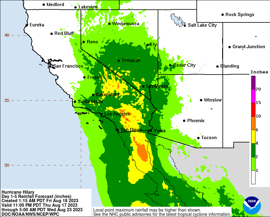
Hilary could bring excessive rainfall, which has the potential for extreme flooding. NWS anticipates 3-6 inches during peak rainfall this weekend. Residents are advised to stay away from beaches and shorelines.
Potential impacts from tropical-storm-force winds, according to NWS, include:
– Damage to porches, awnings, carports, sheds, and unanchored mobile homes.
– Unsecured lightweight objects could be blown about.
– Large tree limbs may be broken off and/or trees snapped or uprooted, especially in places where trees have shallow roots, such as coastal and valley locations that don’t typically experience strong winds.
– Some fences and roadway signs may be blown over.
– A few roads may be impassable from debris, particularly within urban or heavily wooded places.
– Hazardous driving conditions on bridges and other elevated roadways.
– Scattered power and communications outages. Any downed power lines spotted on the roads should not be approached, Bass warns. Call 311 to report a downed line.
Weather officials have encouraged residents to create emergency plans in the case of extreme flooding from heavy rain. NWS warns evacuations and rescues are likely during Tropical Storm Watches.
Bass noted that city fire departments, L.A. sanitation teams, and L.A. Department Of Water And Power restoration crews will be addressing any potential power outages. The Department of Transportation will be staffed to ensure roads are operational. Potential shelter locations have been prepped and identified, along with animal rescue teams being staffed in preparation.
Federal support is also on hand should city officials request it, Bass said.
To prepare for the storm, NWS advises the following actions:
-Secure your outdoor space. Move furniture, umbrellas, and other lightweight items to indoor or secured areas to ensure they don’t fly away
-Gather emergency supplies to shelter in place including food, water, radios, medication, and pet supplies
-Prepare for power outages with batteries, flashlights, backup cell phone chargers and charging cables
-Bring pets inside during the storm to keep them safe from falling debris
-Pick up sandbags from a local fire station.
-Prepare medical devices and cell phones for potential power outages by charging them completely and getting backup systems ready
-Check in on vulnerable neighbors to make sure they know about the storm and are prepared
-Avoid driving if at all possible. Dangerous road conditions are anticipated throughout the region
-Check storm drains in your neighborhood to make sure they are cleared of debris
A list of locations where sandbags are readily available to SoCal residents can be found here. KTLA’s live satellite radar and tracker for Hurricane Hilary can be found here. KTLA’s live blog updates on the storm can be found here.
The L.A. Central Library will be offering free ponchos and other rain supplies to those who need them. Tips from SoCal Edison on how to prepare your home for a storm can be found here.
Residents can sign up for NotifyLA, the city’s emergency alert system. They can also follow the city’s accounts on Twitter, Facebook, or Threads for alerts.
Residents can sign up with CalAlerts for statewide emergency notifications. Drivers can use QuickMap for up-to-the-minute information on road conditions, traffic, closures, and more. Tips on preparing for power outages can be found here.
Metro transit services will be providing information about any impacts or delays to service at Metro.net, thesource.metro.net and on their Twitter page.
The full press conference can be viewed in the video player above.


