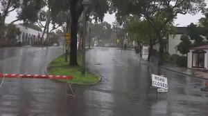
It’s called an “atmospheric river” — basically a river in the sky — that could unleash catastrophic amounts of rain.
And the major storm is barreling right toward the fire-scarred regions of Southern California, with a potential to trigger flash flooding, mudslides and significant debris flow.

The heaviest rainfall is expected Wednesday evening through Thursday, and officials have already ordered mandatory evacuations in Santa Barbara, Ventura and Los Angeles counties.
In Riverside County, Corona city officials issued mandatory evacuation orders for areas burned by the Canyon Fire.
Up to 2 inches of rain have fallen in the burn scar areas since late Tuesday and the worst in Santa Barbara County is expected after dawn Thursday.
“That’s a concern when you put in the heaviest rainfall anywhere in the United States and put it right over Southern California, directly over burn scars,” CNN meteorologist Pedram Javaheri said.
“Some of the areas could see 6 inches of rainfall over 36 hours. That’s six to eight months of rainfall in 36 hours, right over what would be a significant Thomas Fire burn scar region,” he said.
The Thomas Fire, the largest fire in California’s modern history, ignited in December and burned about 281,900 acres in Ventura and Santa Barbara counties.
Santa Barbara County officials have issued a mandatory evacuation order affecting about 30,000 people in extreme and high-risk debris flow areas ahead of the strongest storm of the season in that region. The mandatory evacuation there was effective from noon Tuesday for burn areas near the Thomas, Sherpa and Whittier fires.
The amount of rain and the intensity are enough to cause flooding even without the impact of the recent fires.

“We could experience localized flooding and road closures, which are not isolated to the burn areas. The threat of rock falls, mudslides and debris flow is high,” said Rob Lewin, director of the Santa Barbara County Office of Emergency Management.
Mandatory and voluntary evacuations also took effect at noon Tuesday in Ventura County.
Los Angeles County officials ordered evacuations in areas affected by the recent Creek and La Tuna Canyon fires starting at 6 p.m. Wednesday, and warned other residents living in areas affected by recent fires to prepare for evacuations and street closures.
The large and powerful storm system across the eastern Pacific Ocean is expected to bring periods of moderate to heavy rain through late Thursday or early Friday.
Atmospheric rivers are long, narrow channels that transport water vapors outside the tropics. The one that’s saturating California is known as the Pineapple Express, because it brings moisture from the tropical Pacific near Hawaii and can wallop the West Coast with rain and snow.
The National Weather Service predicts rainfall rates between a half to three-quarters of an inch per hour, with rain totals of 5 to 10 inches in the foothills and mountains. This total is significantly more than during the January 9 debris flow, when there were 3 to 6 inches of rainfall across the region.
Heaviest rain for LA County burn areas expected to be 10 am-8 pm Thu. Slight chance of tstms late afternoon/evening. Peak rainfall rates 0.33-0.66 inch per hour, locally up to 1" per hour near tstms. Potential for flash flooding/debris flows in burn areas. #CAstorm #LArain #cawx
— NWS Los Angeles (@NWSLosAngeles) March 22, 2018


