Hurricane Hilary is expected to make landfall in Southern California on Sunday as a weak Category 1 hurricane or a tropical storm with rainfall amounts ranging from 2 to 10 inches. Refresh page to see the most recent updates below.
Live Hilary Radar | Interactive Storm Tracker | Full Coverage
8:00 a.m. Sunday – Hilary has officially been downgraded to a tropical storm. Max winds of 70 mph and gusts up to 85 mph. Live tracker>>>
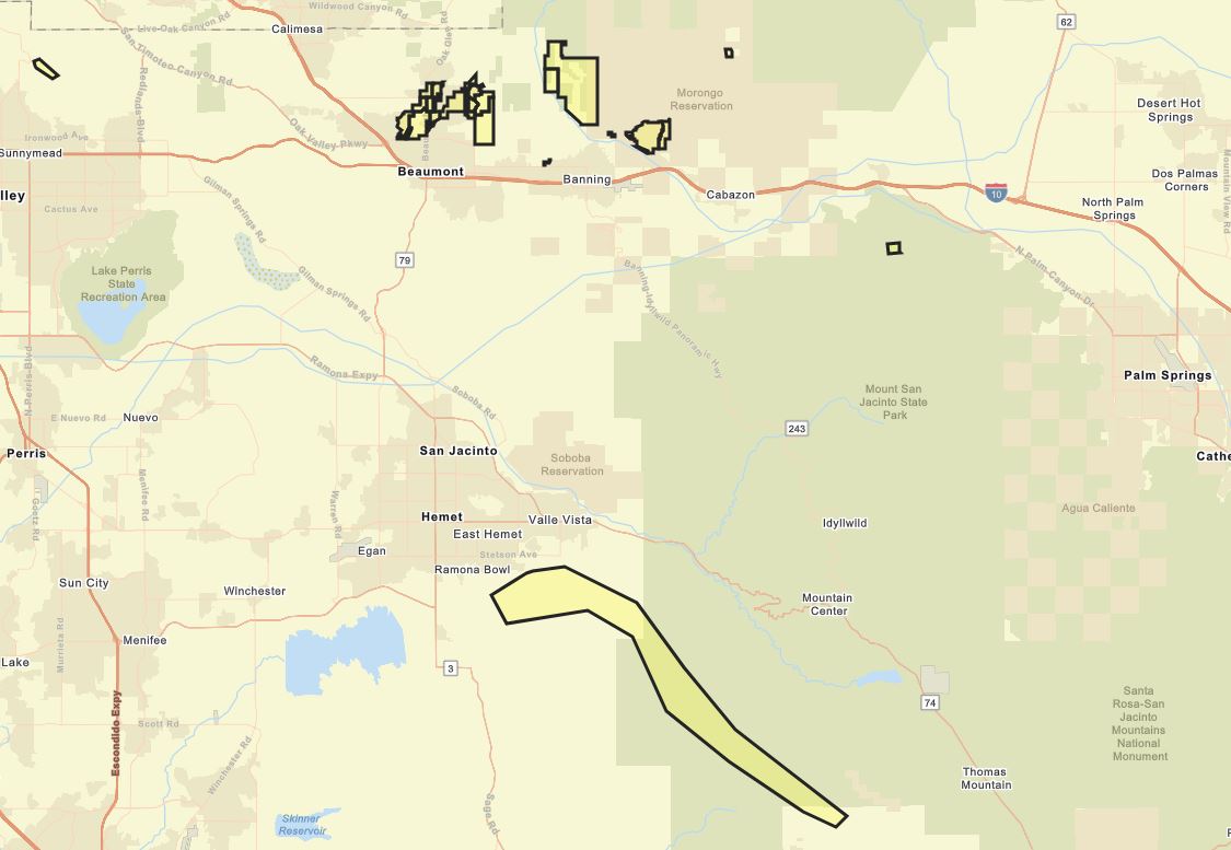
8:00 a.m. Sunday – Riverside County has issued evacuation warnings for the Apple/El Dorado burn scar, which includes parts of Hemet, Beaumont and Banning.
View map: https://tinyurl.com/s76yuy7 #rivconow
7:30 a.m. Sunday – Photo Gallery: Southern California braces for Hilary


7:15 a.m. Sunday – Entertainment canceled for Sunday:
- Six Flags Magic Mountain & Hurricane Harbor
- Hollywood Bowl
- Ciclavia
- L.A. Galaxy Game
- L.A. Zoo
- SeaWorld
7:00 a.m. Sunday – The Los Angeles County Fire Department is warning people to stay away from waterways and river channels.
“The swift moving water can be very powerful and even dangerous.”
6:40 a.m. Sunday – Light to moderate rain is falling in the Inland Empire, where KTLA’s Megan Telles is reporting live.

Light rain was beginning to fall in Los Angeles, Orange, Riverside and Ventura counties Sunday morning and will gain intensity throughout the day. Tap for detailed Hilary rain forecast>>>
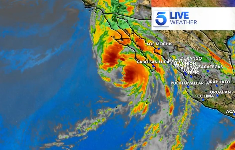
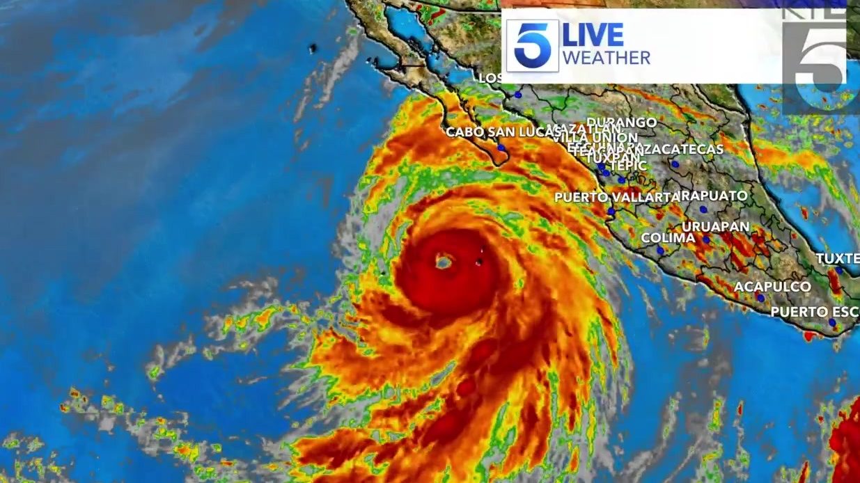
6:30 a.m. Sunday – Current satellite views of Hurricane Hilary.

2:37 a.m. Sunday – From the National Weather Service:
Showers and thunderstorms will spread into Los Angeles County this morning. Later today, widespread rain and scattered thunderstorms will increase as Hurricane Hilary approaches. The peak of this dangerous storm will be from late this afternoon through the pre-dawn hours of Monday morning. Significant flooding and wind threats exist, especially over Los Angeles and Ventura counties. Rain will decrease during the day on Monday. More typical conditions will return on Tuesday, with a chance of afternoon thunderstorms in the mountains.
1:35 a.m. Sunday – An evacuation warning is in effect for residents of the Mountain Cove area in Azusa beginning Sunday at noon and lasting until Monday at noon. The streets affected within Mountain Cove are Highwood Court, Mountain Laurel Way, Moonridge Court and Poppyglen Court.
From the Azusa Police Department:
The Azusa Police Department is issuing a voluntary evacuation warning to a number of residents of Mountain Cove. L.A. County Public Works has issued a Phase 3 Alert for this area. This means there is a risk for moderate to heavy mud and debris flow. If you decide not to voluntarily evacuate, we encourage you to stay vigilant and report and debris and mud flow in your area. Please be mindful of the potential for power outages due to the expected high winds.
11:30 p.m. Saturday – L.A. Mayor Karen Bass declares a local emergency following the activation of the city’s Emergency Operations Center to Level 2.
“As we mobilize and prepare, Angelenos should stay safe and informed by visiting Emergency.LACity.gov,” Bass said. “Stay home, stay safe and stay informed.”
10:50 p.m. Saturday – These American Red Cross shelters are open to evacuees:
– Norman P. Murray Center (24932 Veterans Way, Mission Viejo)
– El Centro Community Center (375 So. 1st Street, El Centro)
– Redlands East Valley High School (31000 E Colton Ave, Redlands
– A list of the nearest shelters can be found here.
10:44 p.m. Saturday – California Attorney General Rob Bonta warned the public against illegal price gouging of items as residents stock up on food and supplies for the storm.
State law generally prohibits charging a price that exceeds, by more than 10%, the price of an item before a state or local declaration of emergency. For any item sold after an emergency declaration, laws prohibit charging more than 50% of the seller’s item cost.
This law applies to retailers selling food, emergency supplies, medical supplies, building materials, gasoline, repair or reconstruction services, emergency cleanup services, certain transportation services, freight and storage services, hotel accommodations, and rental housing.
Violators could face criminal prosecution resulting jail sentence of up to one year and/or a fine of up to $10,000, the AG’s office said. Violators are also subject to penalties of up to $2,500 per violation.
10 p.m. Saturday – Disneyland Resort officials announced the parks will be closing early on Sunday in anticipation of the storm.
“We are closely monitoring tropical storm Hilary and making adjustments based on the latest information from the National Weather Service,” park officials told KTLA. “Our resort hotels will remain open to serve our guests staying with us on property.”
Disneyland Park will close at 10 p.m., Disney California Adventure Park will close at 9 p.m. and the Downtown Disney District will close at 11 p.m. Closure updates are posted on the resort’s website.
8:40 p.m. Saturday – Hilary has been downgraded to a Category 1 hurricane as SoCal braces for the storm’s impact. Experts still predict the hurricane will bring “catastrophic” flooding to the region and across the southwest U.S.
Meteorologists are warning that despite the hurricane’s weakening, the storm’s speed had accelerated on Saturday toward’s Mexico’s coast. The storm is still expected to enter the history books as the first tropical storm to hit Southern California in 84 years, bringing high winds, flash floods, mudslides, isolated tornadoes, and widespread power outages. Up to 10 inches of rain is expected across the Southland.

7:30 p.m. Saturday – Evacuations have been ordered by the San Bernardino County Sheriff for the communities of Oak Glen, Forest Falls, Mountain Home Village, Angelus Oaks and northeast Yucaipa ahead of the arrival of Hurricane Hilary.
The Sheriff’s Department has provided an interactive evacuation map to keep residents up to date. Some mountain communities are expected to be doused with 6 inches of rain, possibly more in isolated areas, as Hilary storms through.
7:20 p.m. Saturday – Los Angeles County search and rescue teams went into Rolling Hills Estates homes impacted by the July landslide to remove hazardous household items and retrieve residents’ personal belongings from red-tagged homes ahead of Hurricane Hilary.
“These residents had just minutes to evacuate. They left behind family heirlooms, passports, birth certificates, treasured belongings. Today LA County is doing everything we can to try to help them recover some of those items,” said Supervisor Janice Hahn.
5:55 p.m. Saturday – All state beaches in Orange and San Diego counties are temporarily closed. Camping activities at impacted areas are canceled and some inland parks were closed due to flooding concerns.
5:45 p.m. Saturday – Governor Gavin Newsom proclaims a state of emergency for most of SoCal to enact response and recovery efforts. Over 7,500 boots on the ground were deployed to help local communities.
“California has thousands of people on the ground working hand-in-hand with federal and local personnel to support communities in Hurricane Hilary’s path with resources, equipment and expertise,” Newsom said. “We’re mobilizing all of government as we prepare and respond to this unprecedented storm.”

5:08 p.m. Saturday – The latest National Hurricane Center track continues with a slightly more eastward track, with the center of the tropical storm making landfall slightly east of San Diego around 6 p.m. Sunday.
5:00 p.m. Saturday – The National Weather Service has released its most detailed forecast to date for the arrival and intensity of rain associated with Hurricane Hilary.
Light rain will begin to fall in Los Angeles, Orange, Riverside and Ventura counties between 6 p.m. and midnight on Saturday, NWS said, and continue through the morning. The rainfall intensifies Sunday afternoon and peaks during the evening and overnight hours into Monday. More info>>>
4:30 p.m. Saturday – A voluntary evacuation warning was issued for Orange County’s Silverado Canyon and Williams Canyon in the Bond Fire burn area. Authorities warn of possible debris flows along or near the burn scar. A map with the areas under the warning can be found here. The warning will stay in place through Aug. 21.
Canyon residents are strongly encouraged to prepare and voluntarily evacuate, especially those with disabilities, access or functional needs, along with residents owning large animals.
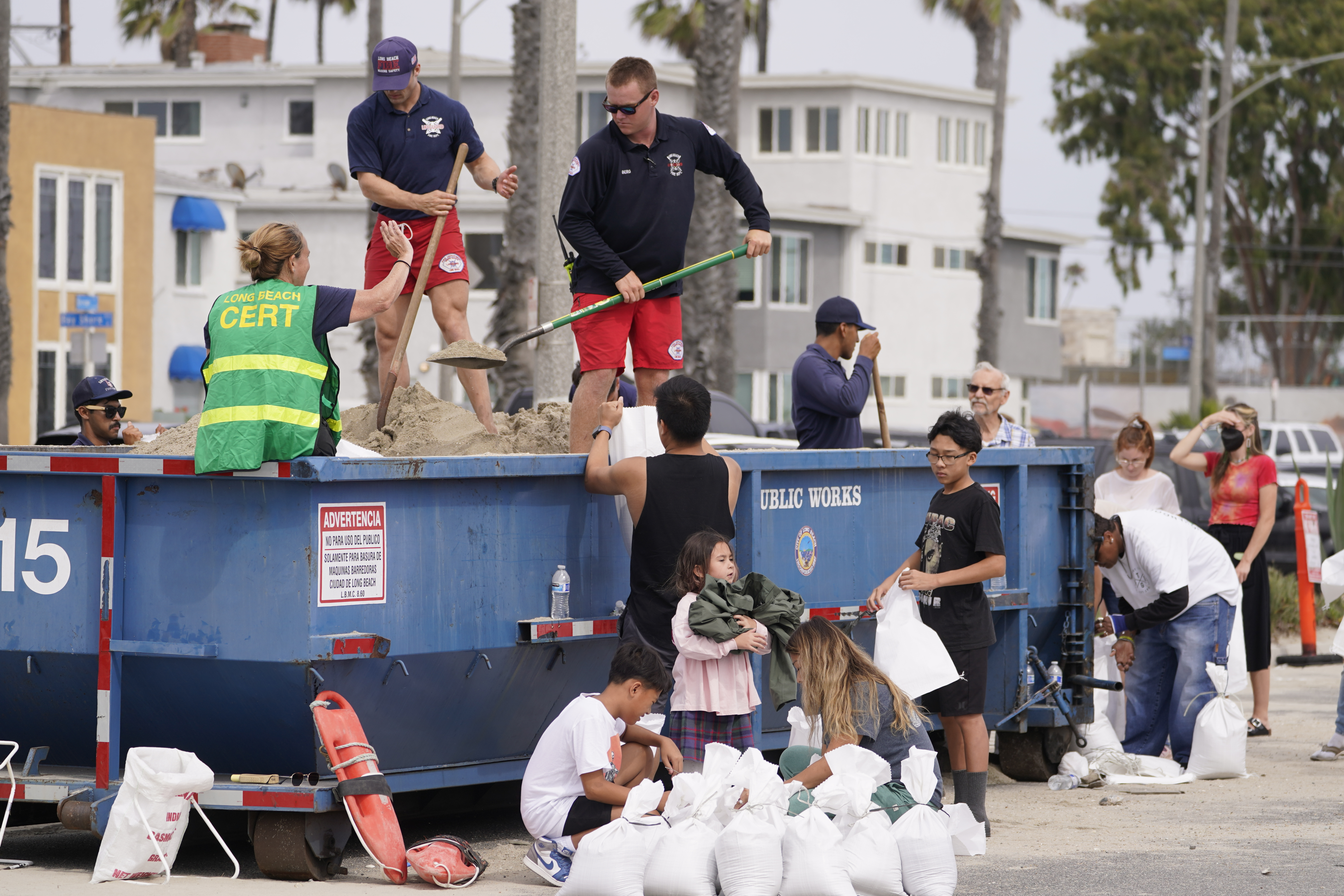
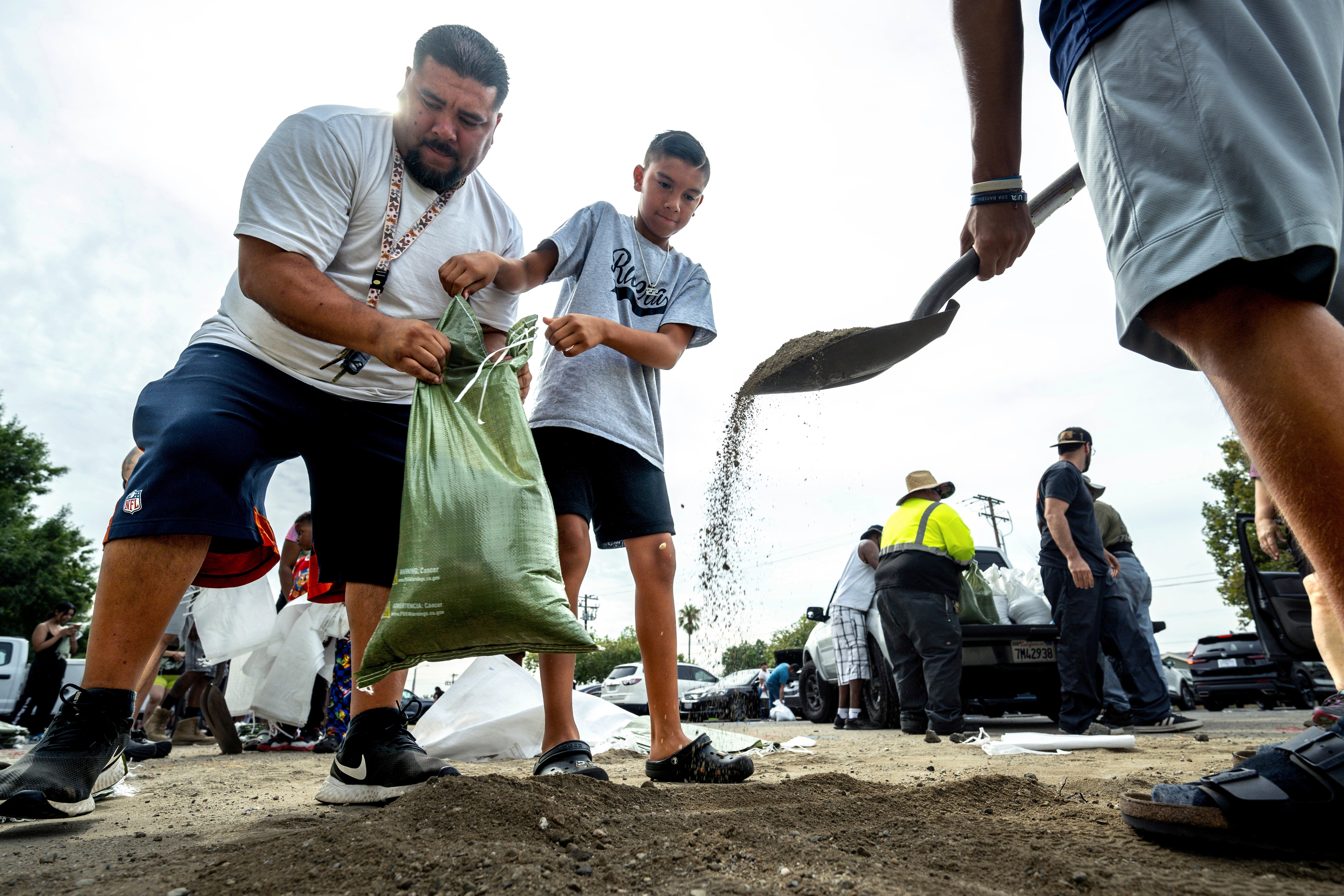
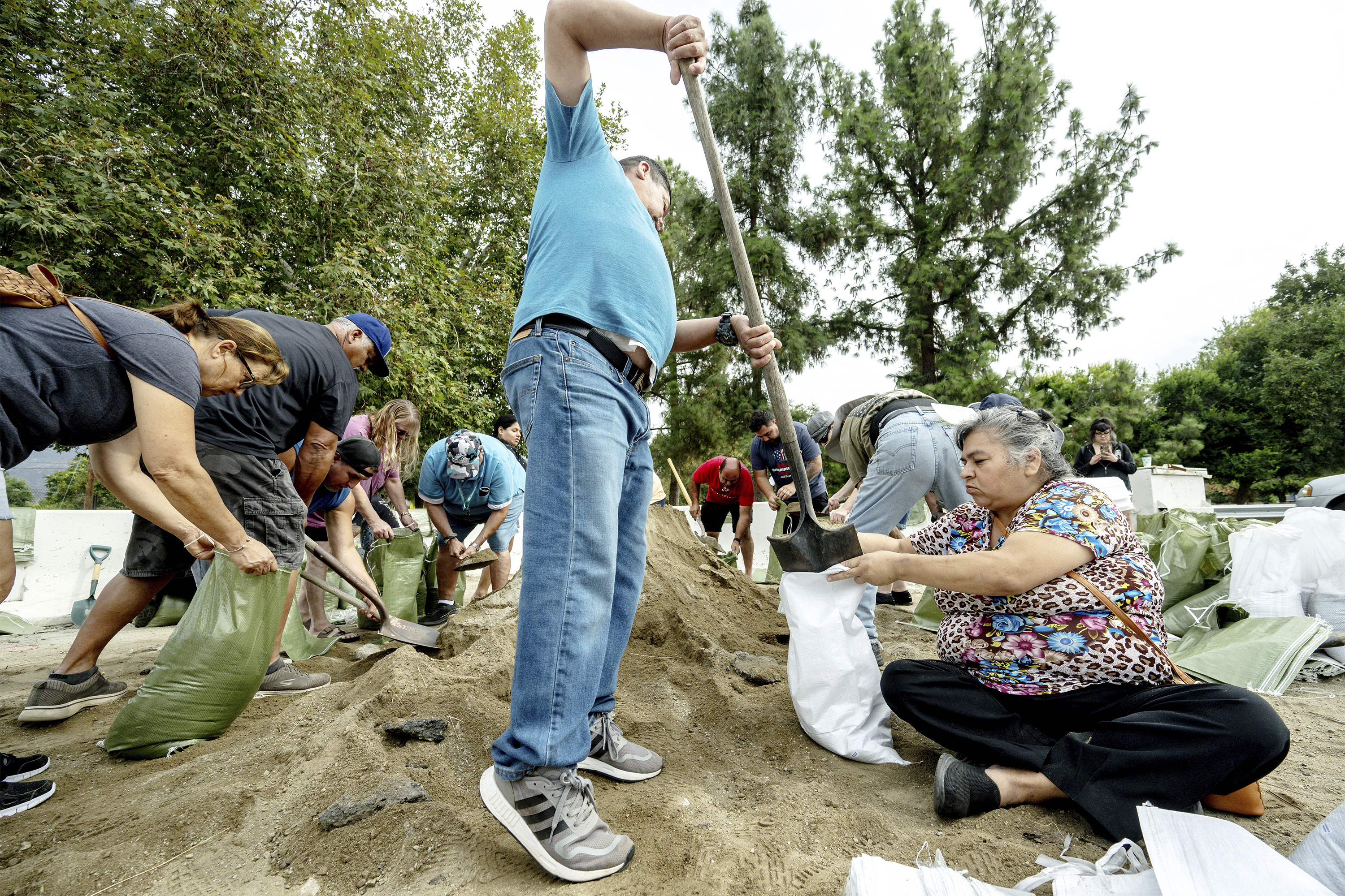
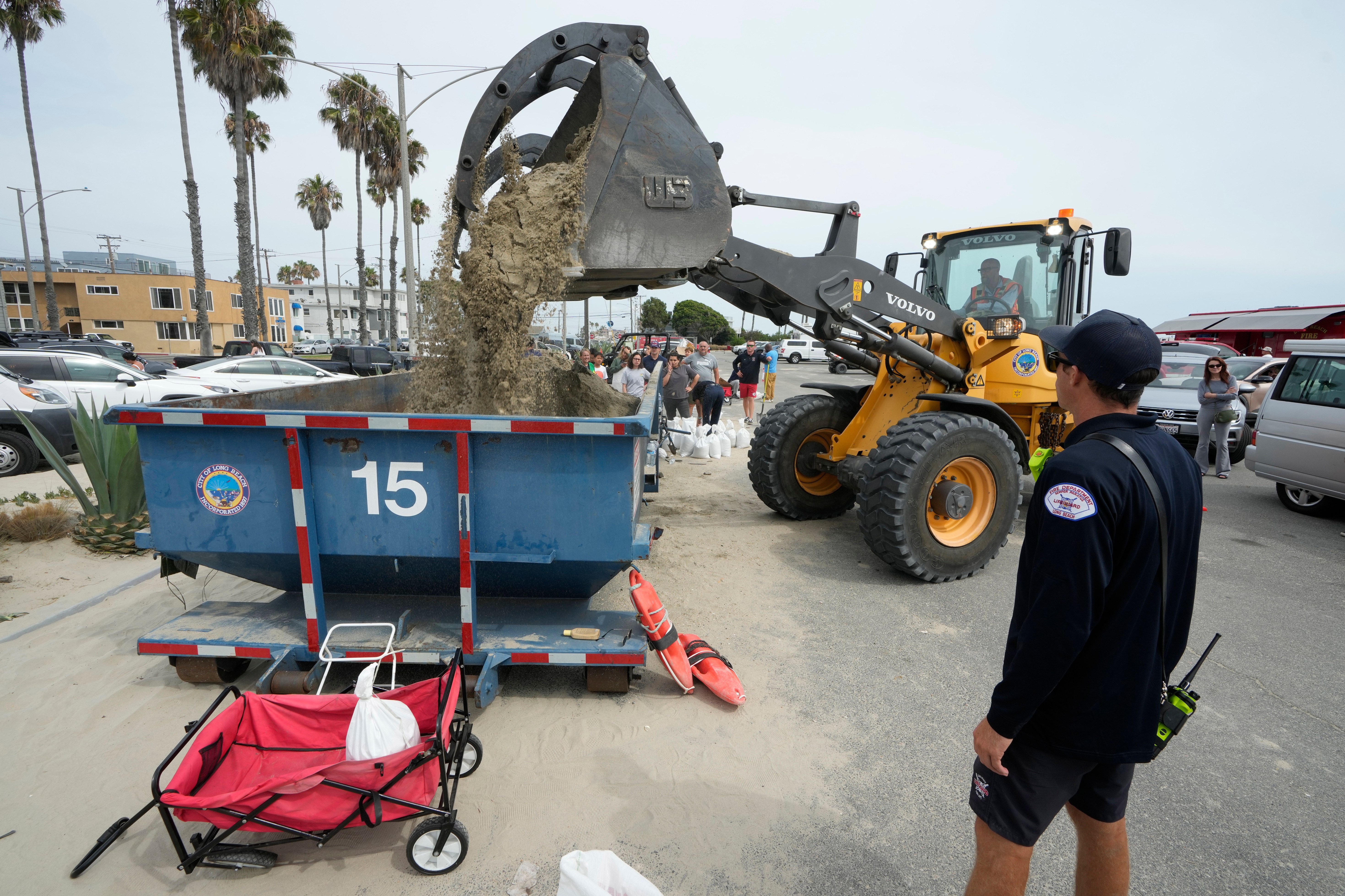
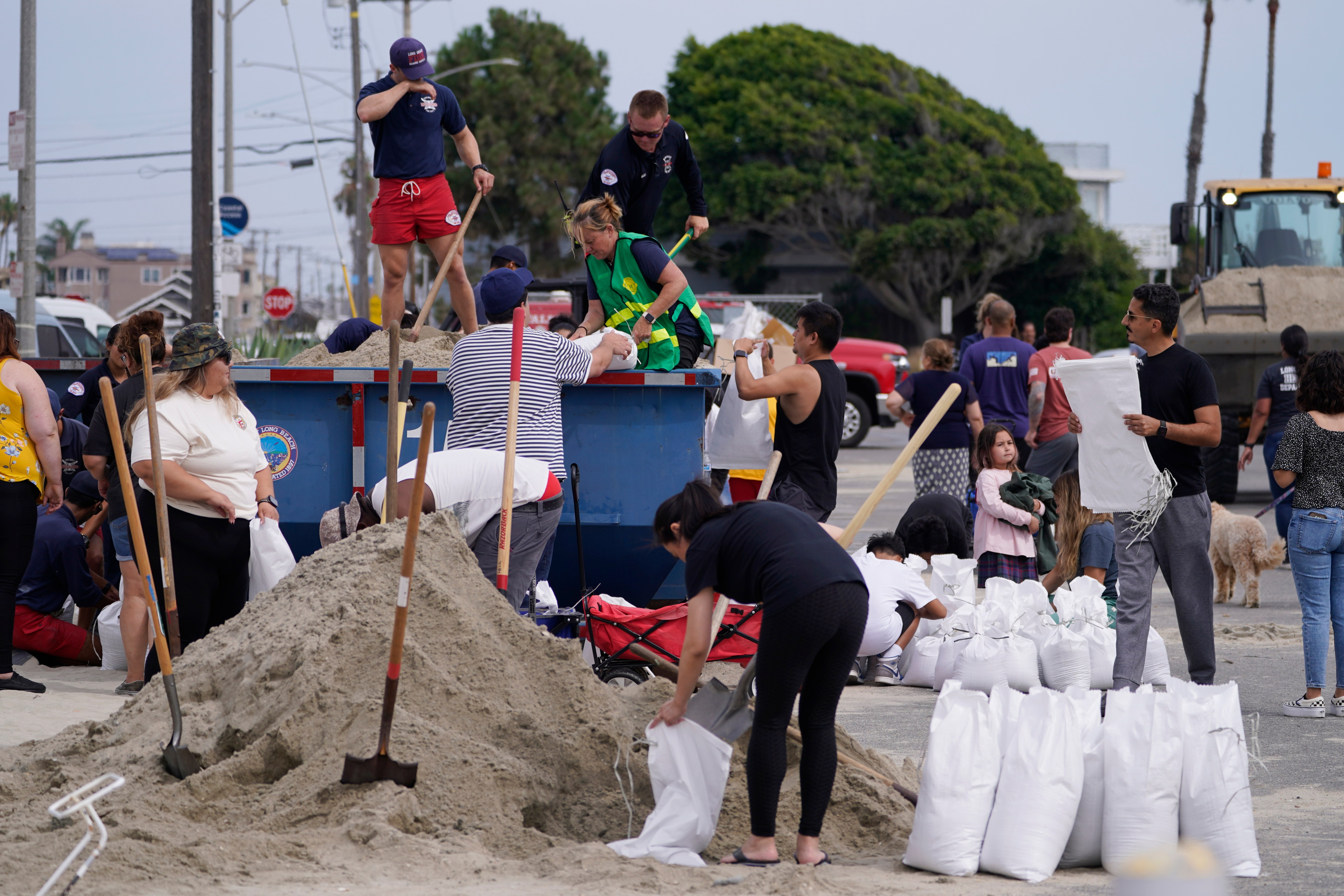
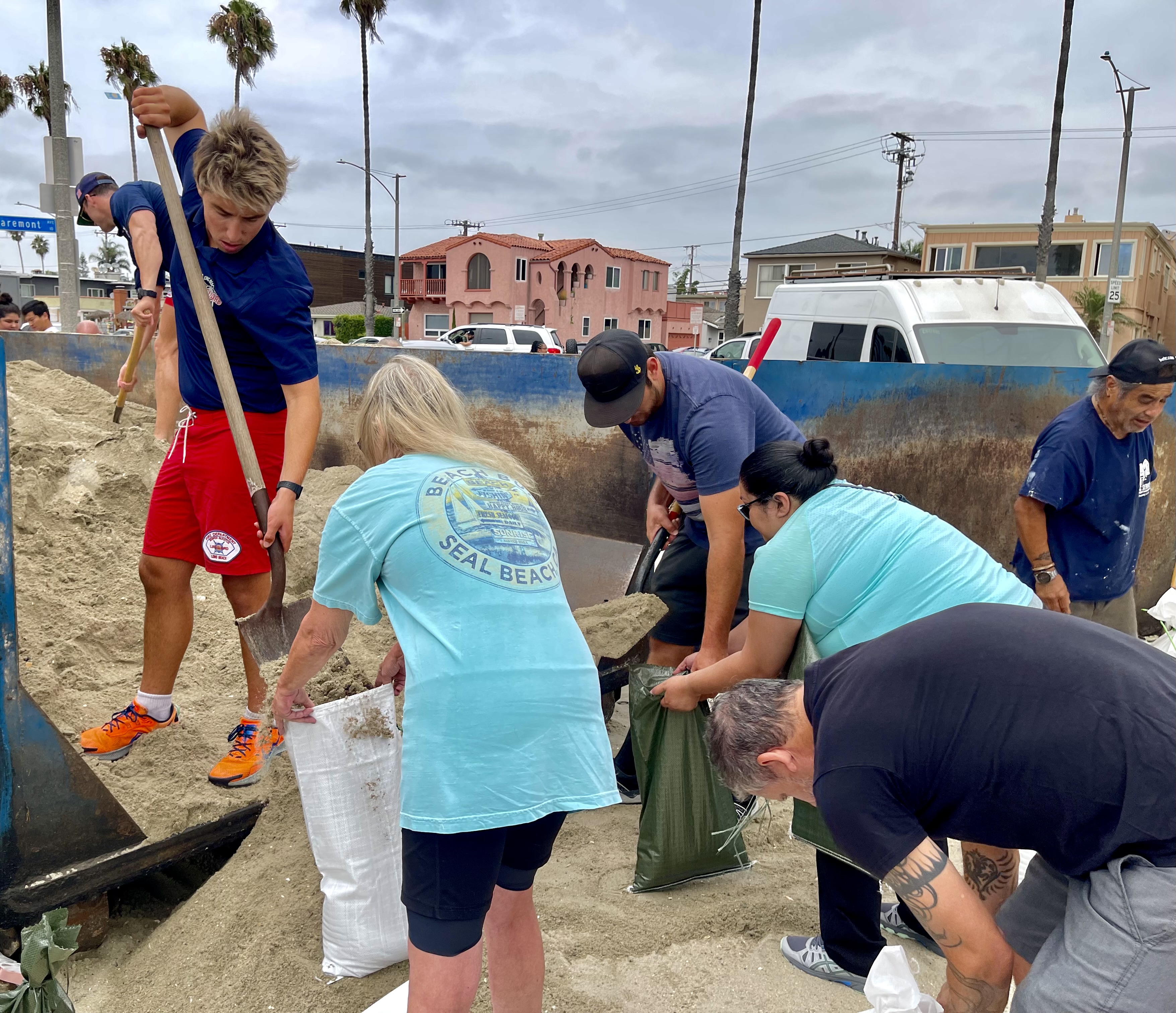
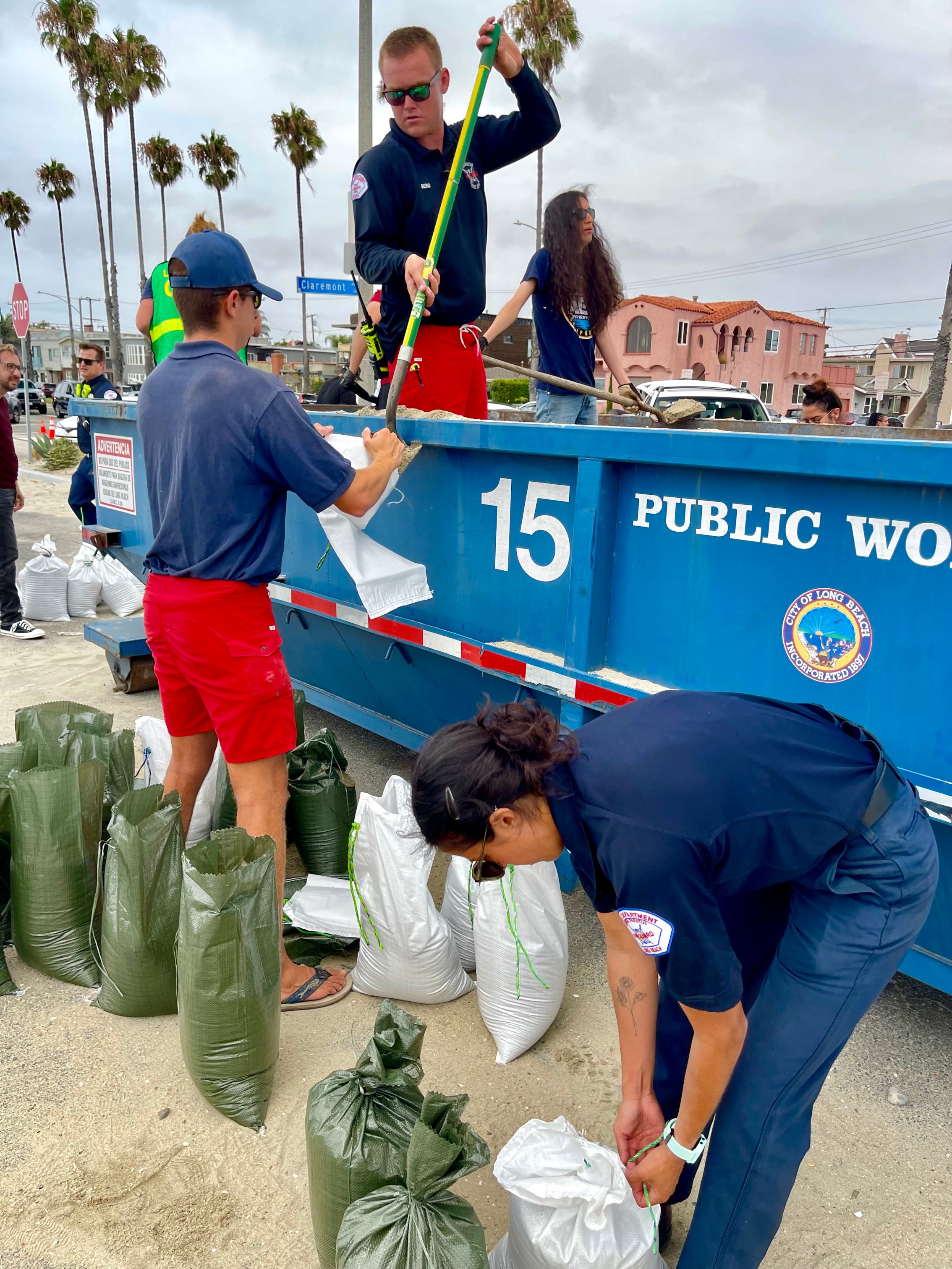
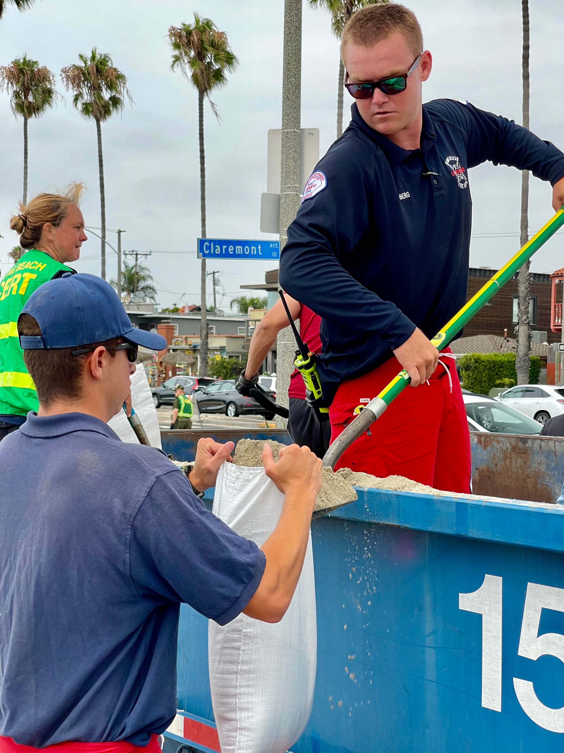
3:50 p.m. Saturday – Coastal communities in SoCal are bracing for potential flooding from Hurricane Hilary. Long Beach residents are filling sandbags for their homes. Protective berms have been built and fortified along the shore. Long Beach Fire Swiftwater Rescue team members are on standby to monitor fast-rising and dangerous waters.
3:20 p.m. Saturday – Hurricane Hilary has been downgraded to a Category 2 storm with maximum sustained winds of 110 mph and gusts up to 130 mph.
1:25 p.m. Saturday – Hilary remains a Category 3 hurricane with maximum sustained winds of 115 mph, down from 145 mph at its peak.
Watch live radar: https://trib.al/cplH1mT
1:05 p.m. Saturday – What can you do to prepare for the storm? NWS offers the following tips:
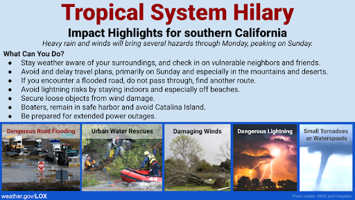
12:30 p.m. Saturday – Los Angeles County Parks will close on Sunday and Monday due to Hurricane Hilary, a press release from the parks department said. All programs and classes are canceled.
All L.A. County parks, buildings and facilities will be closed, including, but not limited to:
- Picnic shelters
- Playgrounds
- Multi-use trails
- Restrooms
- Botanical gardens and arboretums
- Lakes and beaches
- Pools and aquatic centers
- Natural areas and nature centers
- Performance venues
From the Los Angeles County Department of Parks and Recreation:
The L.A. County Parks staff have been working around the clock in preparation of Hurricane Hilary and will remain at parks to monitor safety conditions and impact. The region is expected to experience possible heavy rainfall, high winds, flooding and thunderstorms. Stay away from tall structures such as trees, light poles, picnic shelters and playgrounds.
12:30 p.m. Saturday – CATALINA EVACUATION ADVISORY
From the City of Long Beach:
In response to Hurricane Hilary, the Category 3 storm moving toward California, residents of Catalina Island are being advised to leave the island as a precaution. To assist Avalon, the City of Long Beach will open a temporary shelter to support people who have left the island and do not have any other shelter plans during this unprecedented weather event. The emergency shelter, located at Silverado Park (1545 W. 31st St.), will provide necessities including food, water and beds, as well as basic medical services and is currently set up to accommodate 75 individuals. If additional shelter need is identified, the City would open additional shelter sites throughout the City.
The temporary shelter is expected to receive its first participants midday today, Saturday Aug. 19, and could shelter people until officials deem it safe to return to the island.
Shelter participants will be medically assessed upon arrival and will receive a variety of essential services and access to amenities including:
- Basic medical services and emergency services, if needed.
- Meals three times a day, as well as snacks.
- Access to water.
- Hygiene amenities including indoor and outdoor restrooms, personal hygiene kits and private shower facilities.
- Beds with blankets and pillows.
- Supplies for people evacuating with their pets.
This shelter will serve residents and visitors evacuating Catalina Island only. The island, which home to approximately 4,200 people, is only 22 miles from Long Beach, making our city well equipped to take on evacuees.
Silverado Park has been identified as an emergency shelter site by the City. Silverado Park was selected as it is closest to the Catalina Express, is the City’s largest identified emergency shelter in the City’s shelter plan, and is equipped with showers, cots and other materials needed to support evacuees. No park programming is being impacted this weekend. At any point, if park programming will be impacted due to this shelter or the pending storm, the City will make a public announcement and provide information to registered attendees of those programs. The storm is expected to arrive early Sunday morning, Aug. 20, and into Monday, Aug. 21.
12:15 p.m. Saturday – From Cal OES Director Ward:
Make no mistake, this storm should not be taken lightly. The State’s Operation Center is currently activated 24/7. CA is coordinating with local, state & federal partners. We’ve moved swiftwater rescue teams & high water vehicles. Details>>>
11:35 a.m. Saturday – From LAPD Chief Michel Moore:
As Hurricane Hilary approaches Southern California, the LAPD is closely monitoring the situation, coordinating with local, county and state agencies to strategically deploy resources and respond effectively to any potential impacts. We urge residents to be prepared and stay informed through official channels and to follow safety guidelines as we work together to navigate this challenging weather event.
Los Angeles residents are encouraged to register for alerts through the city’s NotifyLA Emergency Alert System.
Residents are advised to call 311 to report non-emergency or non-life-threatening storm damage.
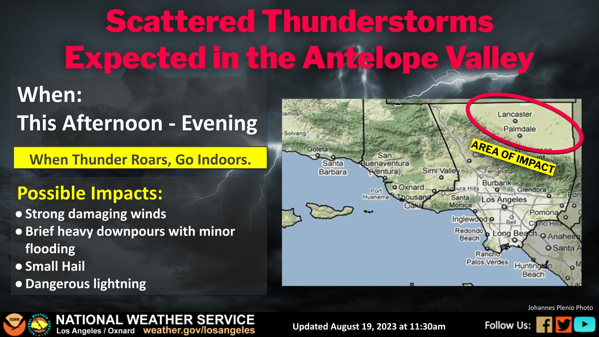
11:30 a.m. Saturday – From the National Weather Service:
Preceding #Hilary there is a high chance of scattered thunderstorms in the Antelope Valley starting this afternoon around 3-5 pm and extending into the evening. Damaging winds, brief downpours, lightning and small hail are possible.
11:20 a.m. Saturday – Hilary is currently a Category 3 hurricane with maximum sustained winds of 115 mph and gusts up to 155 mph.

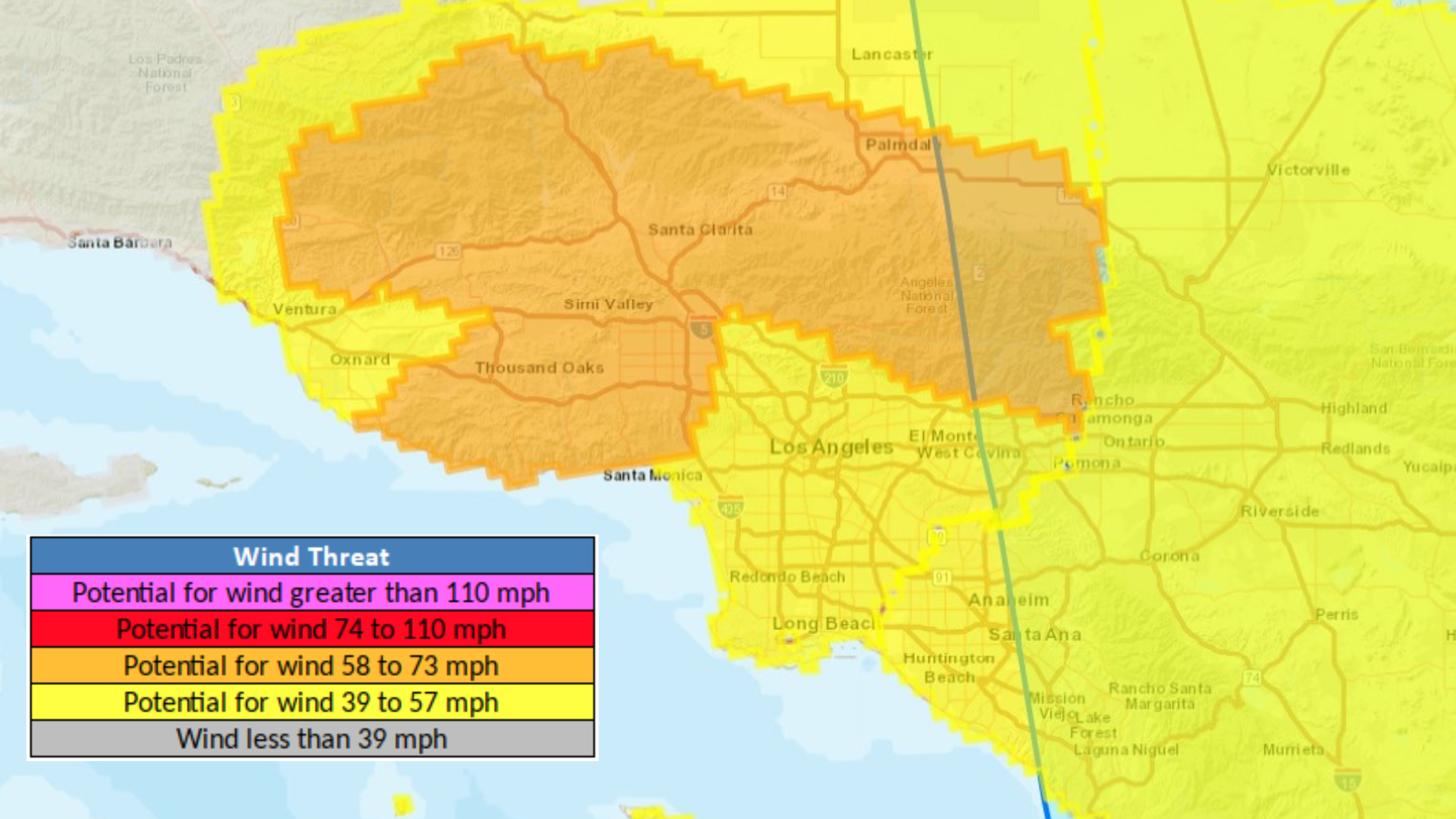
10:20 a.m Saturday – While current peak winds are 130 mph, Hurricane Hilary is expected to weaken over the next 24 hours as it barrels toward Southern California. Peak winds of 39-73 mph are still possible in the Southland, according to the National Weather Service – still capable of causing extensive damage and uprooting trees. Full report>>>
9:03 a.m. Saturday – As Hurricane Hilary makes its way toward SoCal, many residents are preparing for an unprecedented amount of damage caused by the storm.
8:07 a.m. Saturday – From the Los Angeles Emergency Management Department:
- Angelenos should register for NotifyLA for local alerts. The Los Angeles City Emergency Management Department will post updates here. Follow @ReadyLA on social media channels for updates.
- Hurricane safety tips and resources provided by the National Weather Service are available here.
- Los Angeles Department of Transportation Transit Operations will make any announcements involving significant road closures or transportation impacts here.
HOW TO REQUEST SUPPORT
- For impacts like roadway flooding, tree limbs blocking roads, or mudslides, Angelenos should request service through LACity.gov/myla311 or by calling 311. You also download the MyLA311 app.
- In the event of power outages or water main breaks, Los Angeles Department of Water and Power customers can call 1-800-DIAL-DWP or click here.
8:00 a.m. Saturday – From the San Diego Union-Tribune:
The Navy announced late Friday night that it will send many of its warships out of San Diego Bay on Saturday to make it easier to manage and secure vessels that need to stay in port when Hilary slams the region as a tropical storm on Sunday and Monday. Read more>>>
7:40 a.m. Saturday – From the National Weather Service:
The most likely impact from Tropical Storm #Hilary will be rain. The forecast keeps high rain chances between Sunday and Monday night. Rain amounts are less certain due to the exact track and timing.
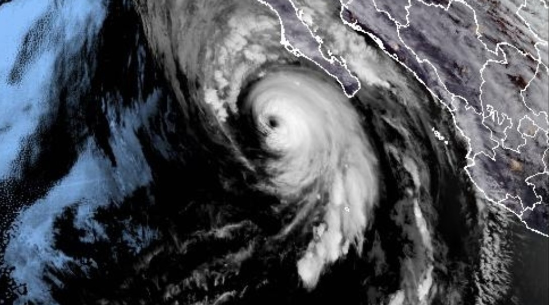
7:20 a.m. Saturday – After rapidly gaining power early Friday, Hilary slowed some later in the day but remained a major Category 4 hurricane early Saturday with maximum sustained winds of 130 mph (215 kph), down from 145 mph (230 kph).
Early Saturday, the storm was centered about 240 miles (390 kilometers) west-southwest of the southern tip of the Baja peninsula. It was moving north-northwest at 13 mph (20 kph) and was expected to turn more toward the north and pick up speed. Full story
6:00 a.m. Saturday – Hurricane Hilary is expected to make landfall as a Category 2 storm south of Tijuana around 11 a.m. Sunday morning.
3:33 a.m. Saturday – The National Weather Service updated the tropical storm warning area to include LAX, Long Beach, Redondo Beach, Santa Monica and Torrance. Wind speeds are expected to be anywhere from 40 to 60 miles per hour.
9:25 p.m. Friday – According to UCLA climate scientist, Dr. Daniel Swain, the greatest risk of widespread and severe flash flooding will hit SoCal mountains on the eastern slopes and the southeast desert region, along with expected stormy conditions across the Southland.
8:30 p.m. Friday – The National Weather Service has upgraded the tropical storm watch for Hurricane Hilary to a tropical storm warning, the first warning of its kind to be issued in SoCal.
All of LA is expected to receive at least a couple of inches of rain, with foothills and mountain areas receiving up to six inches.
This may cause localized flooding with rapidly rising creeks and streams and potential debris flows and mudslides. Unusually strong winds with gusts upwards of 40-60 miles per hour in mountain, valley, and foothills areas, and 20-40 mile per hour gusts across the LA basin could cause damage to unsecured outdoor furniture and roofs.
When preparing for the storm, take the following actions:
-Secure your outdoor space- move furniture, umbrellas, and other lightweight items to indoor or secured areas to ensure they don’t fly away
-Gather emergency supplies to shelter in place, including food, water, radios, medication, and pet supplies
-Prepare for power outages with batteries, flashlights, backup cell phone chargers and charging cables
Sign up to receive text, email, and phone call emergency alerts for your home, work, and school at www.notifyla.org.
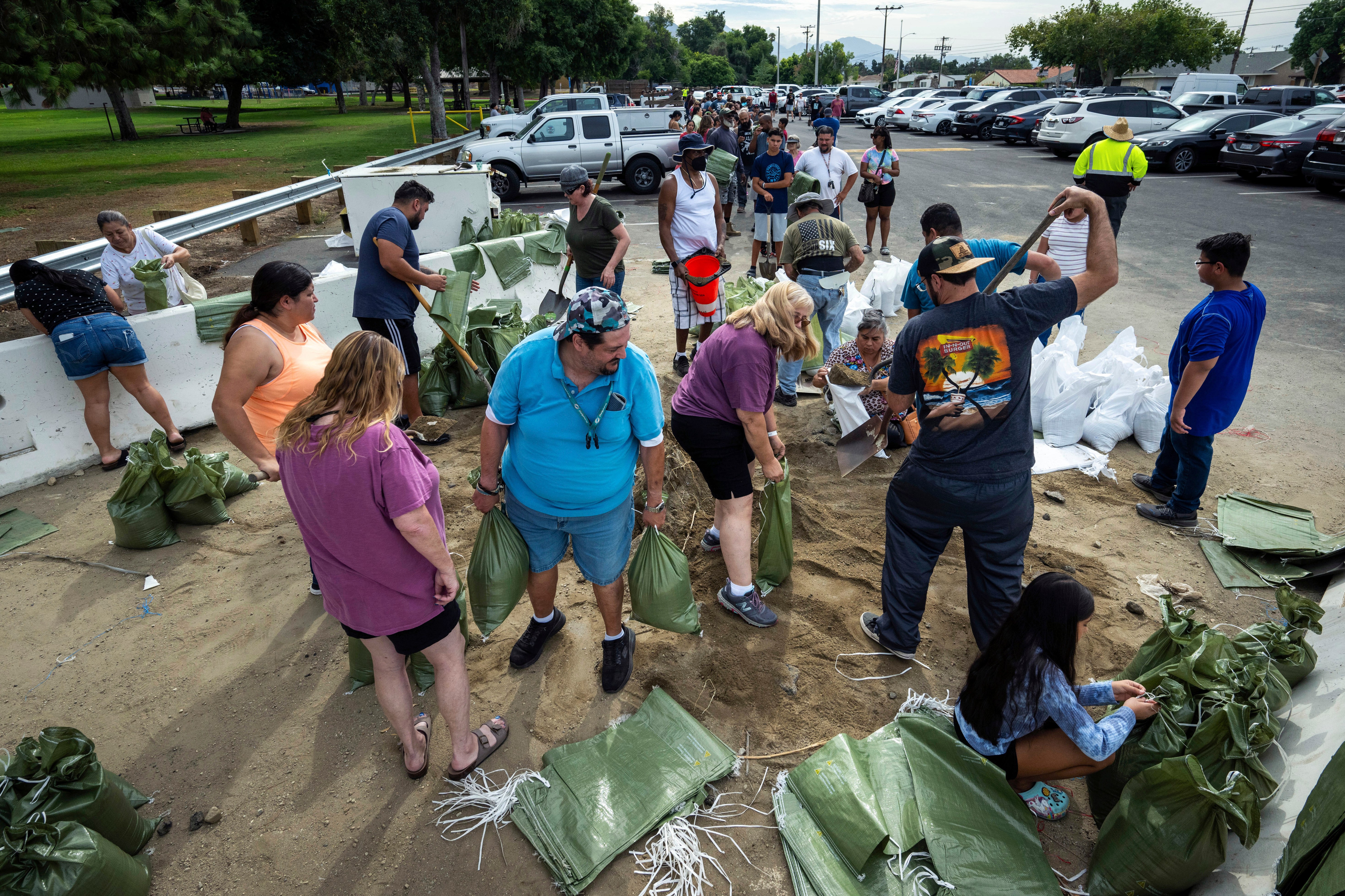
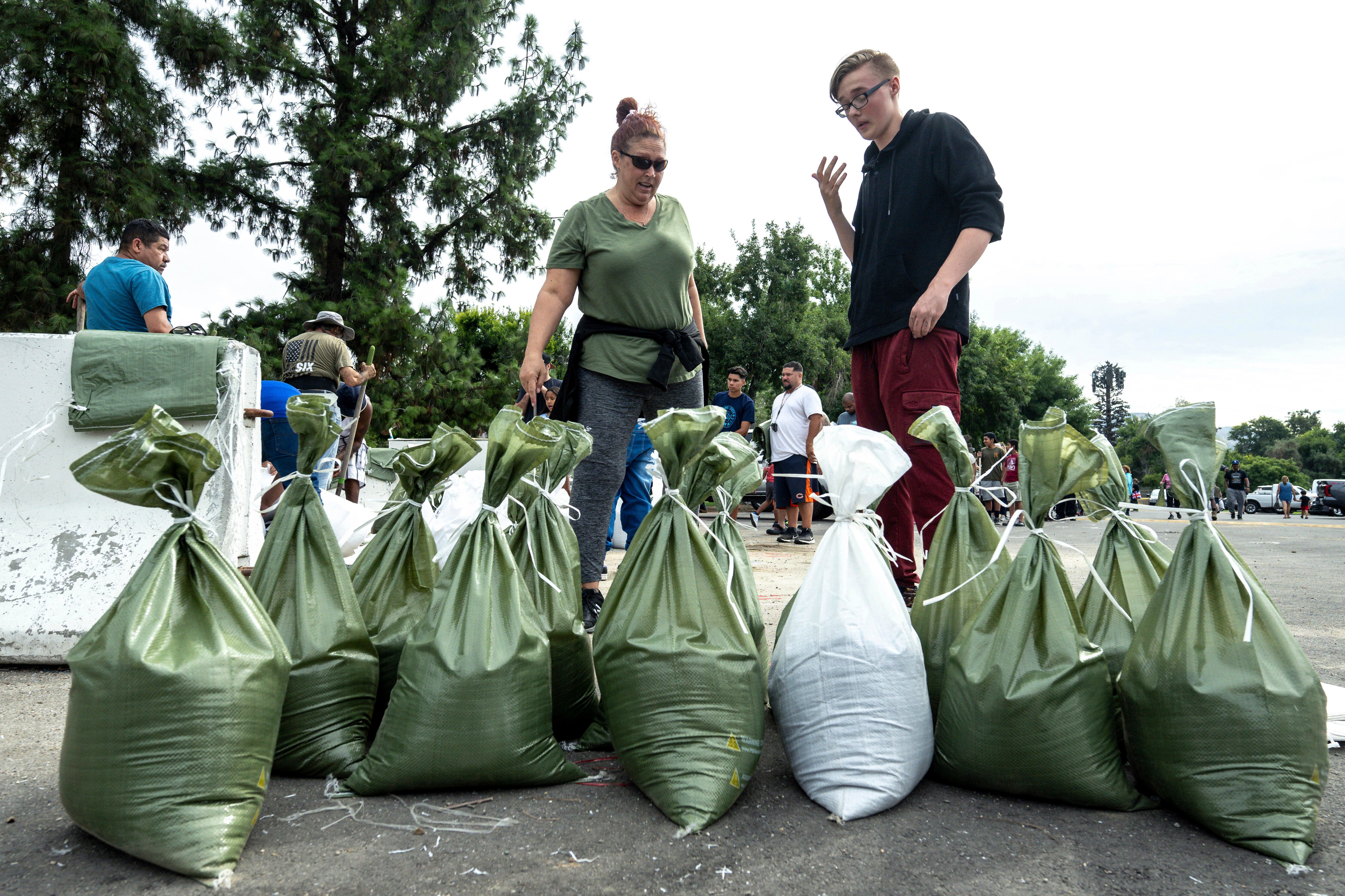
-Pick up sandbags from your local fire station.
-Prepare medical devices and cell phones for potential power outages by charging them completely and getting backup systems ready
-Check in on neighbors to make sure they know about the storm and are prepared
-Check storm drains in your neighborhood to make sure they are cleared of debris
During the storm, the public is advised to:
-Avoid driving if at all possible. Dangerous road conditions are anticipated throughout the region
-Bring pets inside during the storm to keep them safe from falling debris
-Call 911 for life-threatening situations, such as people trapped by flooding or damaged trees, and debris flows threatening buildings
-If you see flooding, fallen trees, or other significant damage that isn’t immediately life-threatening, report it via 311, which will be operating with extended hours during the storm.
-Assume all downed power lines are electrified and dangerous. Report power issues to the Department of Water and Power by calling 1-800-342-5397
-Do not operate generators indoors or in garages. Generator operation tips can be found here.
7:15 p.m. Friday – Residents can sign up with CalAlerts for statewide emergency notifications. Drivers can use QuickMap for up-to-the-minute information on road conditions, traffic, closures, and more. Tips on preparing for power outages can be found here. For impacts like roadway flooding, tree limbs blocking roads, or mudslides, residents can request service through https://lacity.gov/myla311 or by calling 311.
“California is coordinating with federal and local governments to support communities as they prepare for this unprecedented storm,” said Governor Gavin Newsom. “Heed warnings from local authorities, be ready and stay informed.”
6:00 p.m. Friday – KTLA is live-streaming Hurricane Hilary radar through the weekend and until the storm passes. Watch live on desktop or mobile: https://digital-staging.ktla.com/weather/hurricane-hilary-live-satellite-and-radar/
The live feed may occasionally be interrupted for live events, such as news conferences.
5:40 p.m. Friday – “Our schools continue to be one of the safest places for students in the event of inclement weather,” the Los Angeles Unified School District said in a statement Friday afternoon.
In preparation for the storm that is expected to impact Southern California, Los Angeles Unified has engaged in several precautions to ensure the safety of students and employees. All schools have been instructed to review their comprehensive safety plans and emergency protocols, and have communicated with their school communities.
Updates from the District can be found online at LAUSD.org, on social media @LASchools, and on KLCS-TV.
5:30 p.m. Friday – The most recent satellite loop of Hurricane Hilary in the Pacific.

5 p.m. Friday – L.A. Mayor Karen Bass held a press conference to discuss the city’s preparation for the incoming storm. Residents can sign up for NotifyLA, the city’s emergency alert system. A list of locations to grab free sandbags can be found here.
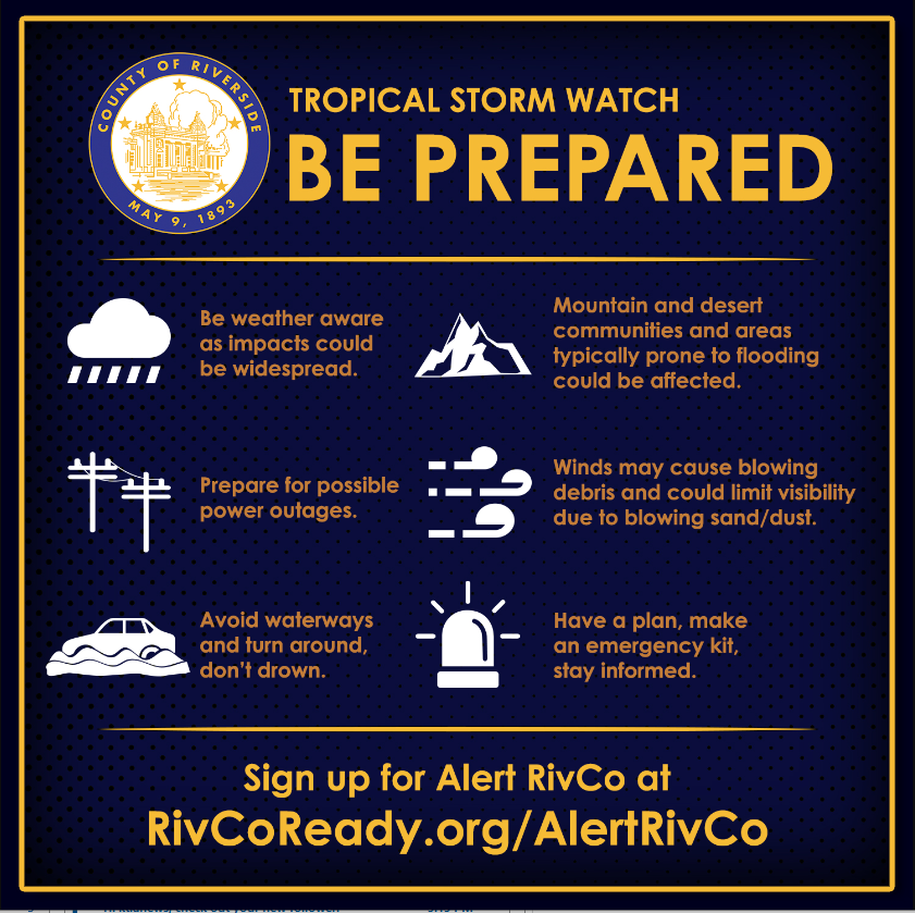
4:31 p.m. Friday – Riverside County is encouraging residents to sign up for official email and mobile alerts at https://rivcoready.org/alert-rivco
4:15 p.m. Friday – The Los Angeles County Metropolitan Transportation Authority released this statement ahead of the incoming storm:
Metro is closely monitoring the situation with the approaching storm. We will be providing information about any impacts to service at Metro.net, thesource.metro.net and at twitter.com/metrolosangeles. Stay safe out there.
4:10 p.m. Friday – The Dodgers and Angels have moved their respective Sunday home games to Saturday due to predicted weather conditions.
The Dodger game against the Miami Marlins Sunday has moved to Saturday and will be a part of a split doubleheader. The game planned for Saturday will take place as scheduled at 6:10 p.m.
Similarly, Sunday’s Angel game against the Tampa Bay Rays has been rescheduled as part of a doubleheader on Saturday.
4:00 p.m. Friday – How much rain can you expect at your home?
The National Weather Service is forecasting 2 to 4 inches of rain in coastal areas and major population centers along the coast and lower elevations. Significantly higher amounts – as much as 10 inches of rain could fall in the mountains and deserts.
3:45 p.m Friday – Southern California Edison provided this update on the utility’s storm preparations:
We’ve been planning ahead for this storm event and have positioned additional personnel, which includes restoration and repair crews, in areas that are expected to receive the most significant impacts. This will allow us to respond to outages in affected areas as quickly as we can safely do so.
2 p.m. Friday – Hurricane Hilary churned off Mexico’s Pacific coast Friday as a powerful Category 4 storm threatening to unleash torrential rains on the mudslide-prone border city of Tijuana before heading into Southern California as the first tropical storm there in 84 years.
Forecasters warned the storm could cause extreme flooding, mudslides and even tornadoes across the region.
Hillary grew rapidly in strength early Friday before losing some steam in the afternoon, with sustained winds falling from 145 mph (230 kph) to 130 mph (215 kph). Nevertheless, it was forecast to still be a hurricane when approaching Mexico’s Baja California peninsula on Saturday night and a tropical storm when approaching Southern California on Sunday.

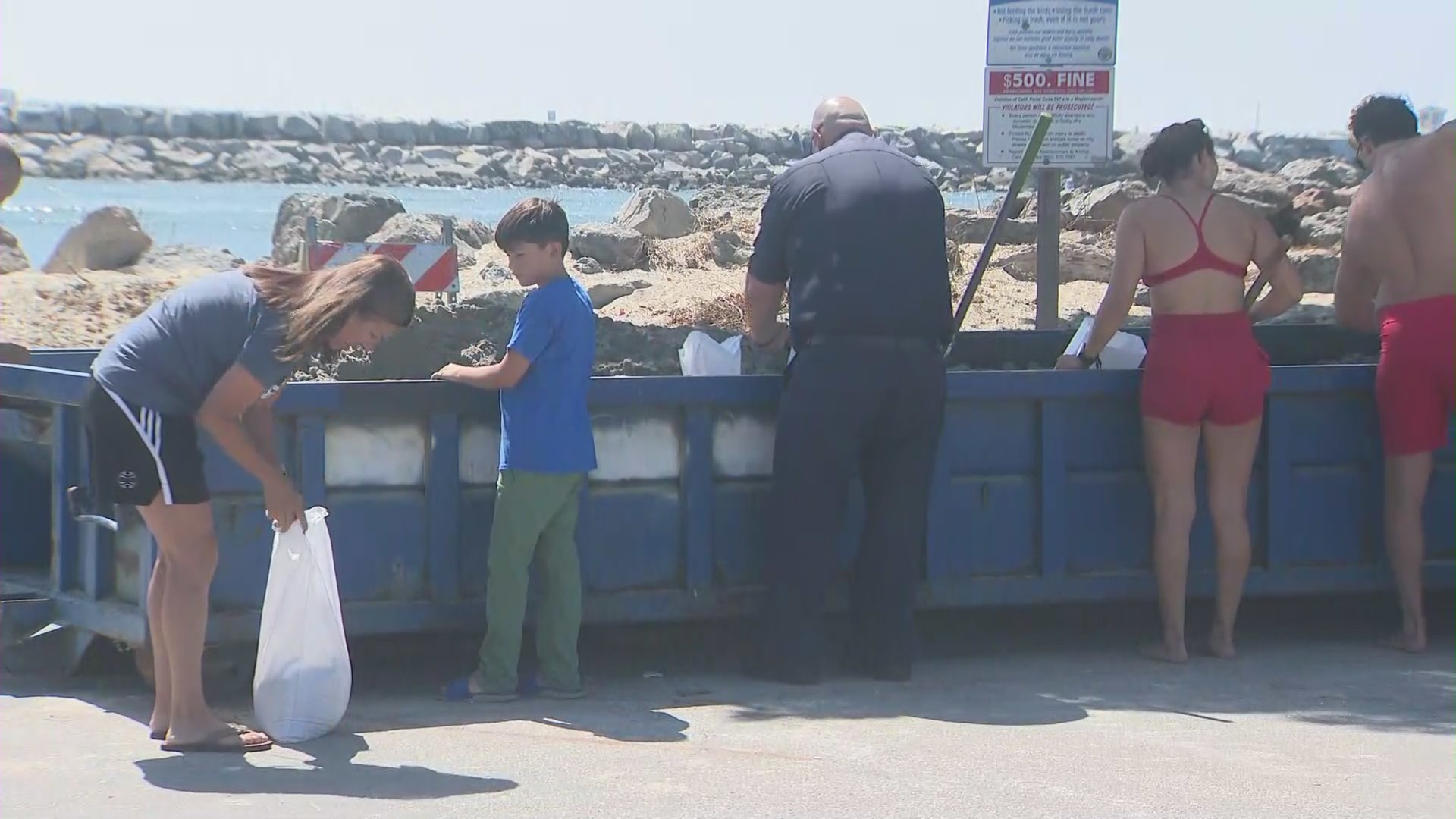
11:30 a.m. Friday – Long Beach residents are filling sandbags and the city is reinforcing ocean berms in anticipation of flooding. Sand and sandbags are available at the following locations:
- Station 7 (2295 Elm St.)
- Station 12 (1199 Artesia Blvd.)
- Station 13 (2475 Adriatic Ave.)
- Station 14 (5200 Eliot St.)
Residents can also pick up sandbags and sand at the lifeguard station at 72nd Place and Ocean Boulevard. A maximum of 10 sandbags are available only to Long Beach residents and identification is required, the officials said in an advisory on Friday.
10 a.m. Friday – Hilary is expected to be the first tropical storm to hit Southern California since 1939‘s Long Beach storm which caused extensive flooding and claimed 45 lives.