A significant winter storm is expected to deliver heavy rain and snow to a wide swath of the United States this week, from the West Coast to the Northeast.
Cold air from Canada will interact with a pair of fronts, causing “numerous weather hazards” and abnormal temperatures while “almost all of the country [experiences] some form of notable weather,” the National Weather Service said.
Snow accumulation of 1 to 2 feet is expected for most mountain ranges across the West, where the storm is arriving at an ideal time to lift the region’s already impressive snowpack.
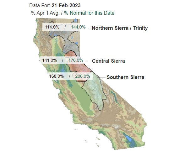
As of Tuesday, snowpack in California was sitting at 174% of normal for Feb. 21, according to the California Department of Water Resources. Regionally, the Southern Sierra was at 208%, Central Sierra at 176% and the Northern Sierra/Trinity at 144%.
The bulk of the Sierra Nevada snowpack, which supplies roughly a third of California’s water, was amassed in December and January when a series of atmospheric rivers hit the Golden State.
February has been considerably drier to date, and water officials have expressed concern that early-season gains could be eroded if the rest of winter returned to the dry patterns that fueled years of drought.
Elsewhere in the Mountain West, Utah’s snowpack was running 125%-177% of normal, and Colorado’s snow water equivalent ranged from 81% to 137%.
The Associated Press contributed to this report.